|
2015 CCVI Trolley Run 4-Mile Sunday, April 26th @ 7:45am FINISH LOCATION... (and parking, buses to start line) Country Club Plaza Ward Pkwy @ Central Street Kansas City, Missouri
While awaiting the second installment of the Heartland 39.3 (Running with the Cows), runners can cool their outsoles at the second installment of the KC Sweet 16 4-Mile Series: The CCVI Trolley Run. The Trolley run has been a long-time featured race on many a runners race calendars: a gorgeous and all-downhill A-to-B route (Waldo to the Plaza) means not only is this one-of-a-kind, but FAST. Proceeds go to the Children's Center for the Visually Impaired in the heart of Kansas City. Packet Pick-Up Thursday, April 23rd, 3:00-7:00pm Friday, April 24th, 10:00am-6:00pm Saturday, April 25th, 10:00am-4:00pm Ward Parkway Mall 8600 Ward Parkway Kansas City, Missouri (also available on race morning in the parking lot of Waldo Mart, at the START LINE) Packet pick-up is located, like so many others, at the Ward Parkway Shopping Center. Given the adequate parking, and that pick-up times are being offered on an unprecedented THREE different days (as well as on race day at the start line), there should be zero problem with traffic. DO NOTE however, UNLIKE other packet pick-ups, this one does NOT take place at Gary Gribble's. Instead, look near the entrance to Target for the pick-up tables. Race Day Parking One of the interesting features of the Trolley Run is its A-to-B format. In other words, different start and finish line locations. For parking, this means parking at the finish line and taking race-provided shuttles to the start line. Finish-line parking is similar to any other race at the plaza (namely, the Plaza 10k): whatever you can find, take it. Garages will be open and available for free parking, although I've found it easier for entrance/exit if I park on the side streets (everyone seems to want to grab a garage spot instead for some reason). Here's the EXACT Google Maps location of the finish line. Park near here... And just for information's sake, here's the EXACT START LINE location. This is where you will be bused to (and where race-day packet pick-up will be)... Race Day Amenities
Course Preview 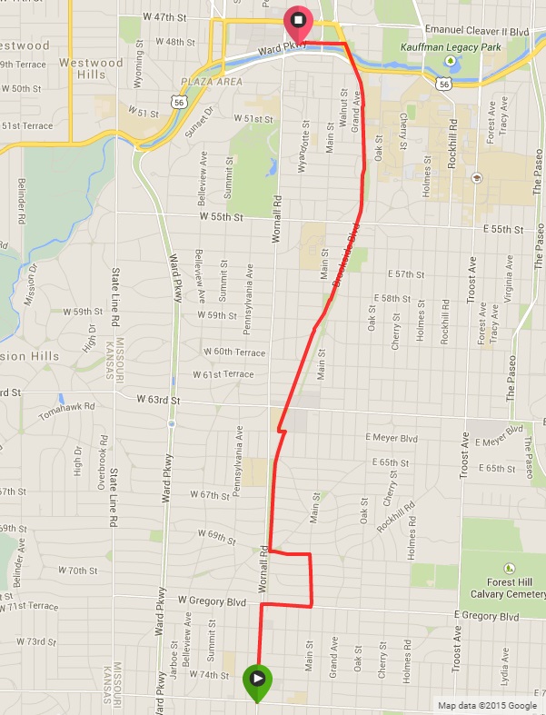 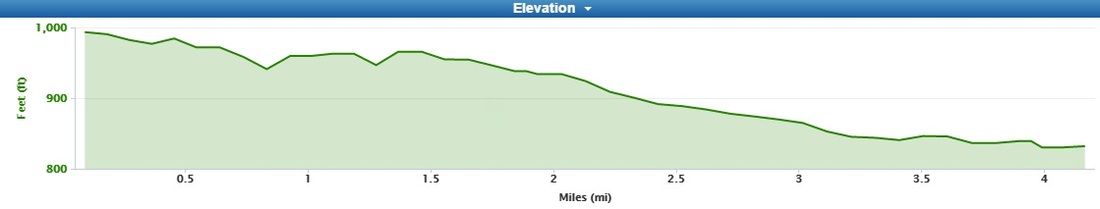 The basics for the 4-mile route...
The joys of a downhill A-to-B! This route nets an overall decrease just over 350 feet, while total climbing is less than half that, at only 150. In fact, nearly all the climbing happens on the first half of the course. With that, we could easily break down the course in to two... Start Line to Mile Marker 2 Though all the climbing happens in the first half of the race, there's still a net downhill, with 180ft of descent, and only 120ft of total climbing. The bulk of that climbing comes in the form of three "speed bumps," each less severe than the last, and each starting at miles 0.75, 1.25 and just past 1.50. After being bused from the Plaza, runners will start in the heart of Waldo, at 75th and Wornall. The opening miles are northbound and downhill, straight up Wornall to Gregory Boulevard, where runners take a right heading east at just past half a mile. The first is the 'largest', but only climbs about 30 feet -- hardly "significant" in my book. If concerned anyways, it starts right at 0.80mi, and lasts just over a quarter mile. Average grade on this one is 2.7%. A quick turn heading north on Main Street will show runners mile marker 1 at the corner of 69th and Main. Another left at 69th, followed by a right puts runners on Brookside/Wornall heading north again. Climb two is shorter, at only 0.20 miles in length, starting at nearly exactly 1.25 miles in. Same grade here, but over a shorter distance. And finally "climb #3" is hardly a climb at all, with only 15 feet gain over a tenth of a mile. Not even 2%. The route continues along Brookside Avenue past Meyer, which means a quick double switchback left on Meyer, then back north on Brookside. At this switchback is when the real downhill portion of the course begins, as runners pass mile marker 2. 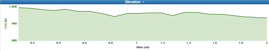 The elevation profile from the start through mile 2. Relatively flat, with two small bumps on the way (and sort of a third, which isn't visible here). (Image Credit: Garmin) Mile 2 to Finish Line The route stays on Brookside Avenue all the way north to the Plaza, over Brush Creek, before turning left on to the final quarter mile stretch on Ward Parkway to the finish line. The entire remainder of the route is downhill and FAST. The final quarter mile is nearly flat, however. Take advantage, and nail that PR!  That's all I got!
=-tds
0 Comments
"KC Multisport Resource" will be changing names (and thus, website domains) soon, so as not to conflict with an area organization with a similar name. The new name will change to "Racing Staples KC" with the URL www.racingstapleskc.com. The URL change will likely not happen until mid-year, upon which time a separate announcement will be made.
Once the URL change is made, future URL entries of www.kcmultisportresource.com will redirect to www.racingstapleskc.com (for approximately 6 months). 2015 Westport St. Patrick's Day 4-Mile Saturday, March 14th @ 10:00am Westport, Kansas City, Missouri
New this year, is the St. Patrick's Day 4-Mile's inclusion in the KC Sweet 16 4-mile race series; also included are the CCVI Trolley Run, Ward Parkway Four on the 4th, and the KC Zoo Run. All races in the series have been running event staples in the area for quite some time, so it only made perfect sense to round them all up together. The Westport St. Patrick's Day 4-Mile is the first in the series, always held in-line with the Westport St. Patrick's Day parade. Packet Pick-Up Friday, March 13th, 10:30am-6:00pm Gary Gribble's Running Sports Ward Parkway Shopping Center 8600 Ward Parkway Kansas City, MO Packet pick-up is also available on race-day at Manor Square lobby (near the start line). Race Day Parking Participants and spectators are urged not to park along the race route (see below), as vehicles may be towed. Near the start line (and surrounding areas), all Westport parking areas are fair-game. The start line is near the corner of Westport Road and Mill Street (with the race route heading west), so parking at any of the lots along Westport Road to the east of there seem to be the best bet. Given the location of the start line (as well as the start time being near business hours), I would avoid the World Market parking lot (they may even have it blocked off), although don't take my word for it -- for the Westport Santa Dash 5k in December, may seemed to find parking there perfectly suitable. However, parking in the lot just east of World Market, on the east side of Mill Street, is a safe bet, as well as the spots along Mill Street to the south of the start line. The approximate location of the start line is shown in the following map... NEW SECTION! -- Race Amenities
Course Preview (with Virtual Run) Introduction & Route Basics 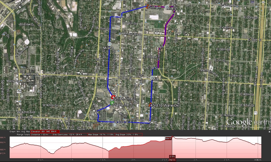 A Google Earth view of the route. I highlighted the second major climb on-route to show it's false-flat near the top. Though I didn't participate last year, I understand the route is the same (and was the same in 2013 as well). There are a few climbs on-route, two significant of note. Here are the basics...
Climbs Two on-route, although there is a third smaller climb near the start line. The second major climb is sorta beastly.
Virtual Run (all images credit to Google Earth Street View unless otherwise noted) 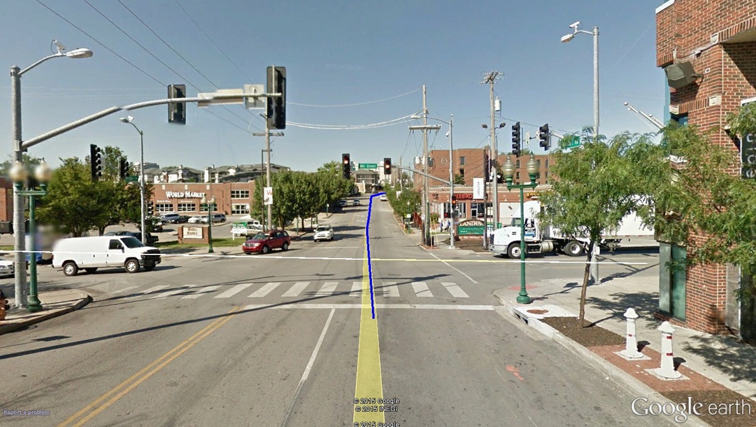 Mile 0.00: Approximate location of the start line. The start takes off from the intersection of Westport Road at Mill Street, in front of World Market and The Landing shopping center (where Jerusalem cafe is). The route heads west on Westport Road. The opening meters are actually a down-hill kick -- a nice way to grab some quick momentum -- followed immediately by an up-hill. The first climb isn't a "significant one," per se (i.e. not, covered in the climbs descriptions above), but it is noticeable. 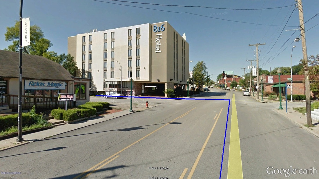 Mile 0.20: The turn off of Westport Road and on to Clark Avenue. Nearing the top of the opening mini-climb, runners come off of Westport Road and left on to south-bound Clark Avenue. Just after turning on to Clark, climbing stops and a HUGE downhill begins. Keep in mind: what elevation you lose, you will have to gain back. 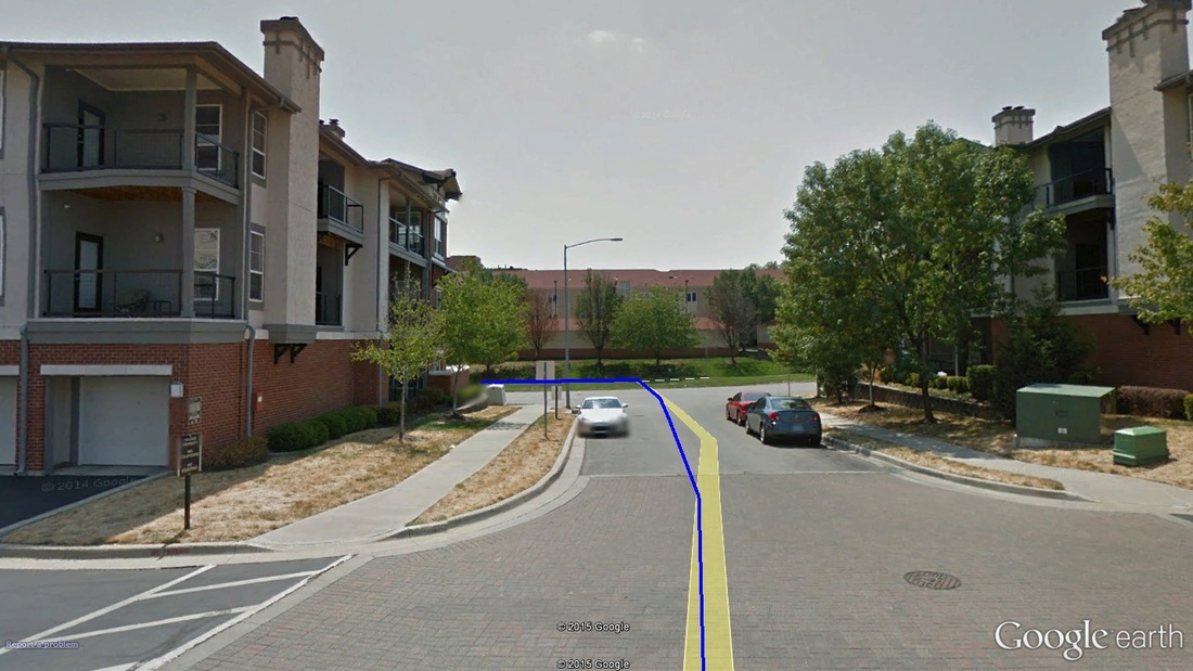 Mile 0.30: The quick turn off Clark and on to West 43rd Avenue. Almost as immediately as the turn on to Clark, runners take another left off of Clark and on to West 43rd. The drop continues, however, all the way to Broadway. 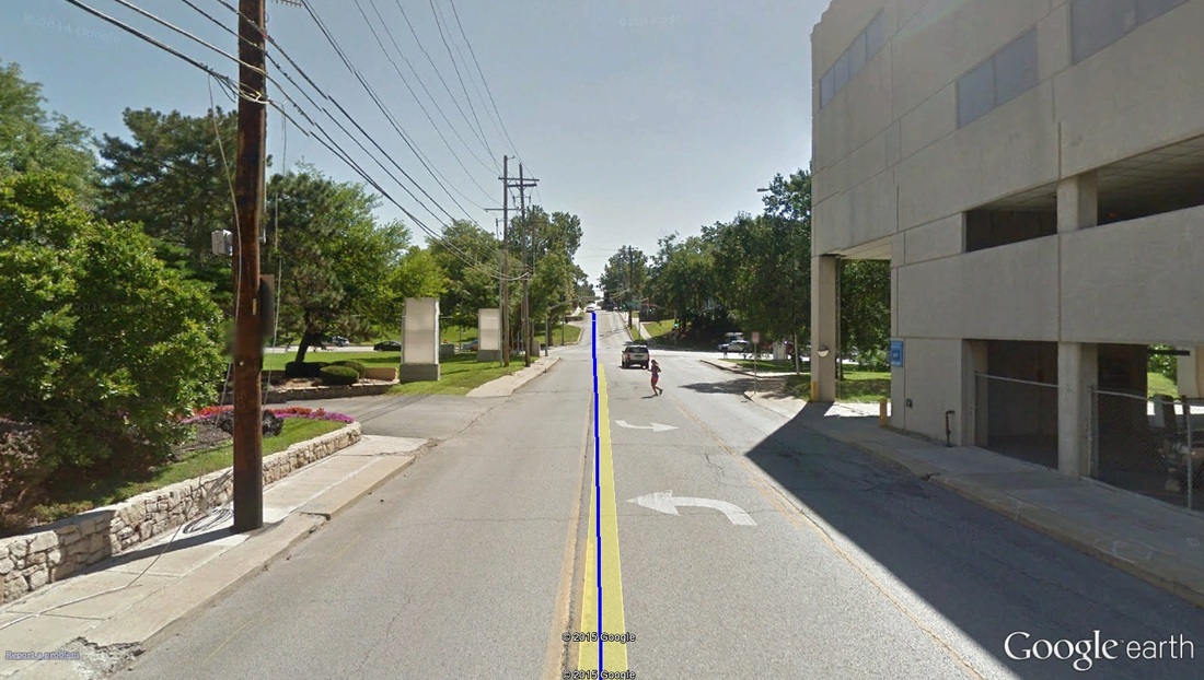 Mile 0.70: The base of climb 1 (43rd to Warwick). Google Earth even caught a runner enjoying this stretch as well...hello, runner! About halfway along the West 43rd stretch, nearing Broadway Boulevard, the drop stops and abruptly makes up all the elevation lost -- about 75 feet in the span of half a mile. 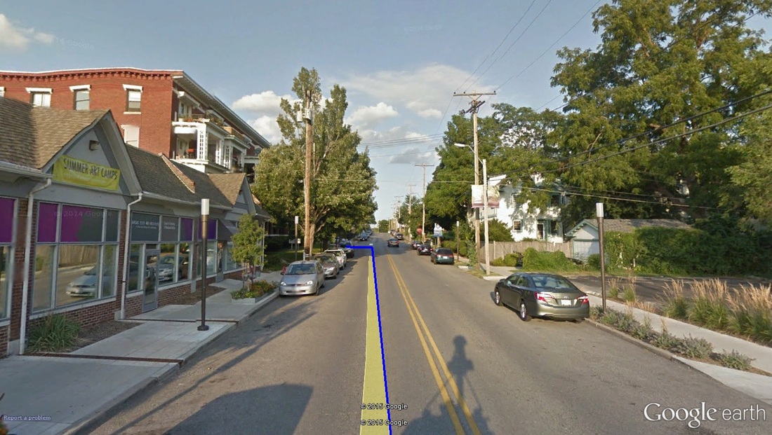 Mile 0.90: The turn off of West 43rd and on to Warwick. The climbing continues, however. At nearly 1 mile in, and halfway up the 43rd-to-Warwick climb, runners take another left off of West 43rd, now heading north, on Warwick Boulevard. Mile marker 1 is just beyond the turn, and nearly to the top of the first climb. At about 1.1 miles, the first climb tops out, and runners begin another descent, almost-but-not-quite as steep as the last descent. 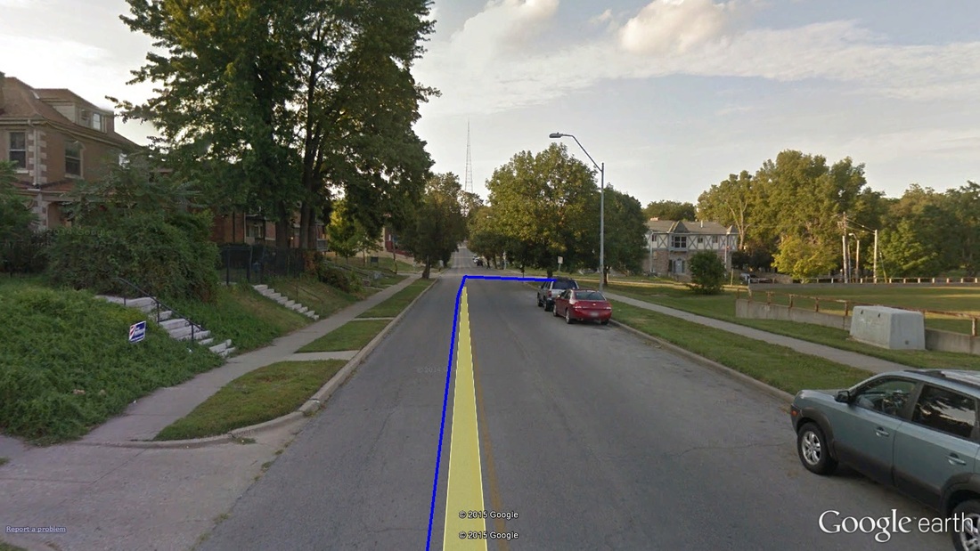 Mile 1.50: A quick turn off of Warwick Boulevard and on to East 38th Street... 1.5 miles in, take a right on to East 38th Street heading east. The road continues to drop. Take advantage of this stretch (along 38th) as much as possible! 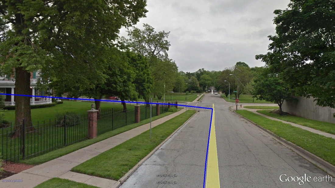 Mile 1.60: ...and then a quick turn off of East 38th and on to Gillham Road heading north. Not a tenth of a mile later, runners turn off of East 38th and on to Gillham Road. This turn marks the end of the descent and the start of the second climb. Those familiar with running north on Gillham Road (i.e. KC Marathon) will know, it climbs nearly the entire way, and wears on the legs quite a bit. It's not steep, but just steep enough to challenge. For the St. Patrick's Day route, this stretch of Gillham will climb for nearly a mile at 2.5% average grade (but nearly 8% at some points), and up just over 100ft. 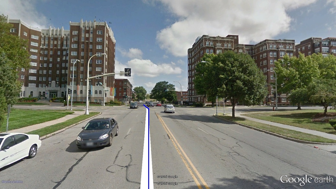 Mile 2.00: The climb up Gillham continues through Armour Boulevard (pictured). Mile marker 2 should be about here. 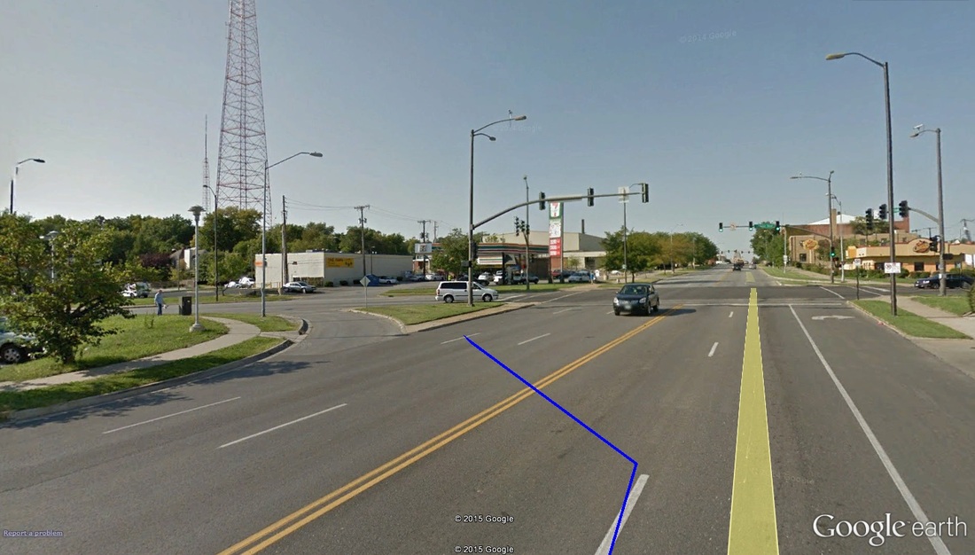 Mile 2.30: Turning off of Gillham and on to Linwood. This also [pretty much] marks the end of the second of two major climbs on-route. At about 2.3 miles in -- 1.7 to go -- runners take a left off of Gillham Road and on to Linwood Boulevard heading west. For me, this would mark a very significant point in the race: all climbs on this route happen in the first 2.5 miles. Coming off of Gillham, you the most significant pitches of the Gillham Road climb have been conquered. There are still a few feet to battle, from here to the finish, but for the most part they are all shallow bits. However, with still over a mile and a half to go, if you can recover from the climbs, you have plenty of time to kick hard to the finish. 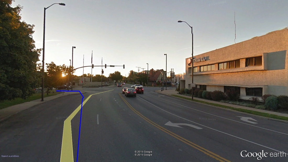 Mile 2.90: Quick left-hand turn off of Linwood and on to Broadway... 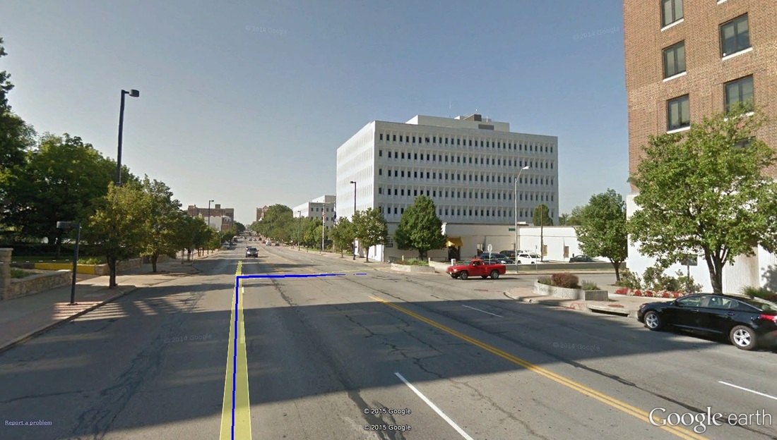 Mile 3.00: ...followed immediately by a right turn off of Broadway and on to West 43rd Street. After about half a mile running on Linwood, runners will take a left heading south on Broadway, followed almost immediately (about 100 meters later) with a right-hand turn on to West 43rd Street. The turn on to 43rd Street should come with it the 3rd mile-marker. 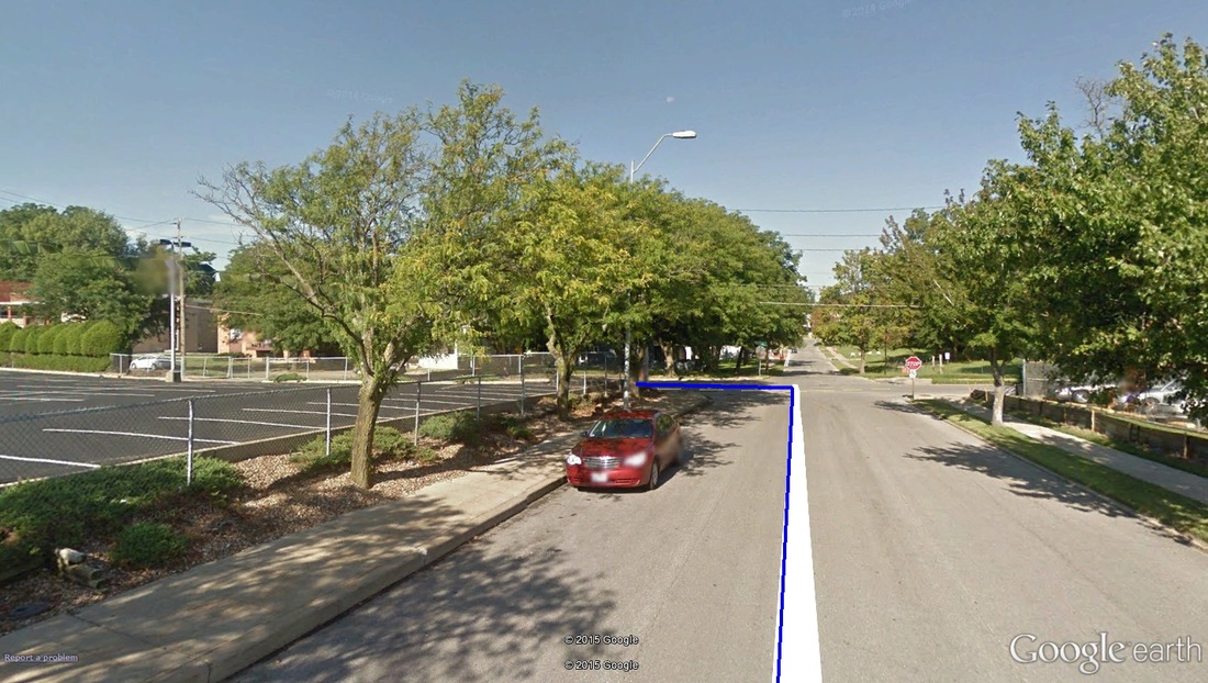 Mile 3.10: A left turn from 43rd to Pennsylvania Avenue south. Just past mile marker 3, runners take a left off of 43rd Street and on to the longest single-road stretch on the course, southbound Pennsylvania Avenue. About 3.4 miles in (1k to go), there is a slight up-hill on Pennsylvania -- about as steep and long as the climb just off the start line -- that will only cause headache if your legs are feeling sloppy. Let's face it -- at this late a point in any race, all up-hills feel mountainous. 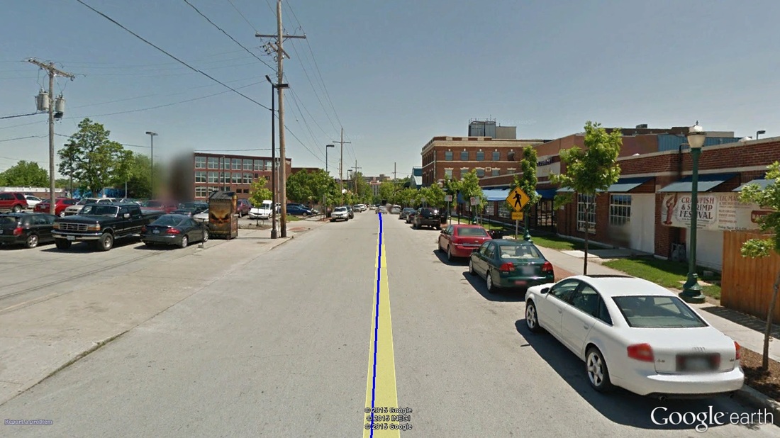 Mile 3.90: The final meters, the Beaumont club on the right of the image. From 3.6 miles on, the road is all downhill. Enjoy the quick finish! The finish line sits in front of Manor Square (just short of Kelly's), around the corner from the start line. Grab a medal and a water -- you've earned it!
-tds ~~__o _-/<,_ @/ @ 2015 ALS Road Race Series Sundays, March 1st, 8th & 15th First rider off at 10:00am Lake Perry, Kansas
Criterium racing (or road race, as it were) has found its way back to my season calendar after a two-year hiatus (Tour of KC last year doesn't count). I'm a bit nervous, but excited all the same. Given my lack of base training (I'm working on that), it should be quite the challenge. Race Day Parking & Check-In Race day parking will be located on the western-most portions of the race route, with most of the parking just south of the start line. Take Hwy-24 to Perry, Kansas, exiting north on to Kansas 237. Take an immediate right on to 22nd street all the way to Dam Road. Take a left on to Dam Road (which is the western edge of the race route -- so if you're arriving after 10am, you may hit some road closures), following it to the start-finish area. Parking will be on the left and right side of the roads, with the race-day check-in to the right of the start-finish line (and EXACT location is provided below). Race Day Schedule The race day schedules for each of the three days (March 1st, 8th & 15th) are nearly the same, with only the number of laps changing for each category. The official schedule run-down, along with field sizes, prizes, and registration fees, can be found at the USA Cycling registration page HERE. The following is the schedule run down for each of the three days... Sunday, March 1st START TIME GENDER/CATEGORY LENGTH (# LAPS) 10:00am Men / Masters Cat 1-5 40/50/60/65+ 4 laps 10:03am Men / Cat 5 4 laps 11:50am Women / Cat 4 3 laps 11:52am Women / Masters Cat 1-4 40/50+, Cat 1-5 60/65+ 3 laps 11:54am Men/Women / Junior 14-18 2 laps 11:54am Men/Women / Junior 9-13 1 lap 1:00pm Men / Cat 1/2/3 6 laps 2:30pm Men / Cat 3/4 5 laps 2:35pm Women / Cat 1/2/3 5 laps Sunday, March 8th START TIME GENDER/CATEGORY LENGTH (# LAPS) 10:00am Men / Masters Cat 1-5 40/50/60/65+ 5 laps 10:03am Men / Cat 5 5 laps 11:50am Women / Cat 4 4 laps 11:52am Women / Masters Cat 1-4 40/50+, Cat 1-5 60/65+ 4 laps 11:54am Men/Women / Junior 14-18 3 laps 11:54am Men/Women / Junior 9-13 2 lap 1:00pm Men / Cat 1/2/3 7 laps 2:30pm Men / Cat 3/4 6 laps 2:35pm Women / Cat 1/2/3 6 laps Sunday, March 15th START TIME GENDER/CATEGORY LENGTH (# LAPS) 10:00am Men / Masters Cat 1-5 40/50/60/65+ 6 laps 10:03am Men / Cat 5 6 laps 11:50am Women / Cat 4 5 laps 11:52am Women / Masters Cat 1-4 40/50+, Cat 1-5 60/65+ 5 laps 11:54am Men/Women / Junior 14-18 4 laps 11:54am Men/Women / Junior 9-13 2 lap 1:00pm Men / Cat 1/2/3 8 laps 2:30pm Men / Cat 3/4 7 laps 2:35pm Women / Cat 1/2/3 7 laps Course Preview Introduction The ALS Road Race Series -- formerly the "That Dam Road Race" of years ago -- was actually my very first cycling race, way back in 2008. Though I actually haven't returned since (always opted for the Spring Fling Criterium Series the Saturdays before), the route hasn't changed since. The lengthy circuit, along with lap-number-format edges this away from criterium and in to the road race category (or circuit race). At almost exactly five miles per lap, the loop is long, and features the dreaded Dam Road hill -- tacked at the least 3 times per race. Route Basics 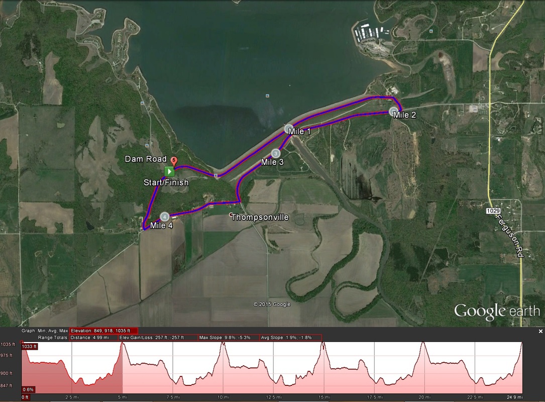 The route with elevation profile. The elevation profile shows five laps. I've highlighted one lap. (Image credit: Google Earth) Here are the basics for the 2015 route...
Climbs One significant climb on-route (per lap), which really lends to this route's infamy. Since this is a circuit, it's not uncommon (especially in category 5 and 4 races) to see riders attack early, only to explode the third and fourth time up. It starts off with a few minor blips, the opening mile only an average grade of just over 1%. The final half-mile, after the turn on to Dam Road, is where it really kicks -- hard -- with a 5% average slope, some spots at 8%. Seems like not-so-bad, but at-speed, upwards of 8 times over, it starts to wear on the legs.
Virtual Ride Roger Harrison of Lanterne Rouge Kansas gave a nice little tour of the route via auto in January of this year. You can access the video (via his Facebook profile) HERE. A big thanks to Roger for the video. After the first week of the series, I will post an on-bike video of the route, with embedded metrics and all. That's all for now. Let's just hope for some cooperative weather. -tds ~~__o _-/<,_ @/ @ This is part four of my six-part series on the 2015 Walt Disney World Marathon Weekend. Part four covers the course preview, including Virtual Run feature. Part 1 (Introduction) can be found HERE. Part 2 (History of the Race & Registration Process) can be found HERE. Part 3 (Training & Planning) can be found HERE. Part 5 (Travel, Event Expo, & Pre-Race) will be posted on Race Weekend. Part 6 (Race Day & Post-Race) will be posted after Race Weekend. The event's official website can be found HERE. The event's official Disney Event Guide can be found HERE. By now, training should be in full swing for all participants in the half-marathon and greater. Part of training, though, is knowing the course, and tailoring your training to meet the demands of the route (namely, elevation profile). Luckily, for those with limited outdoor training access (it is winter-ish, after all), this course is pancake-flat. So treadmill training should be relatively adequate. OF IMPORTANT NOTE, however...treadmills are softer, and require less effort. A weekly long-ish run outdoors is HIGHLY recommended so that your joints and bones are also trained for the blacktop-and-concrete race route. Additionally, on treadmill runs, increase the incline to about 0.5%, which should require enough extra effort to mimic the demands of race day. With that, let's take a look at the race route, with Virtual Run photos (courtesy of Google Earth Street View; most of the interior shots of the Walt Disney World parks are not on Street View, and are photos I took myself, unless otherwise noted). Course Preview The Google Maps route can be found HERE. 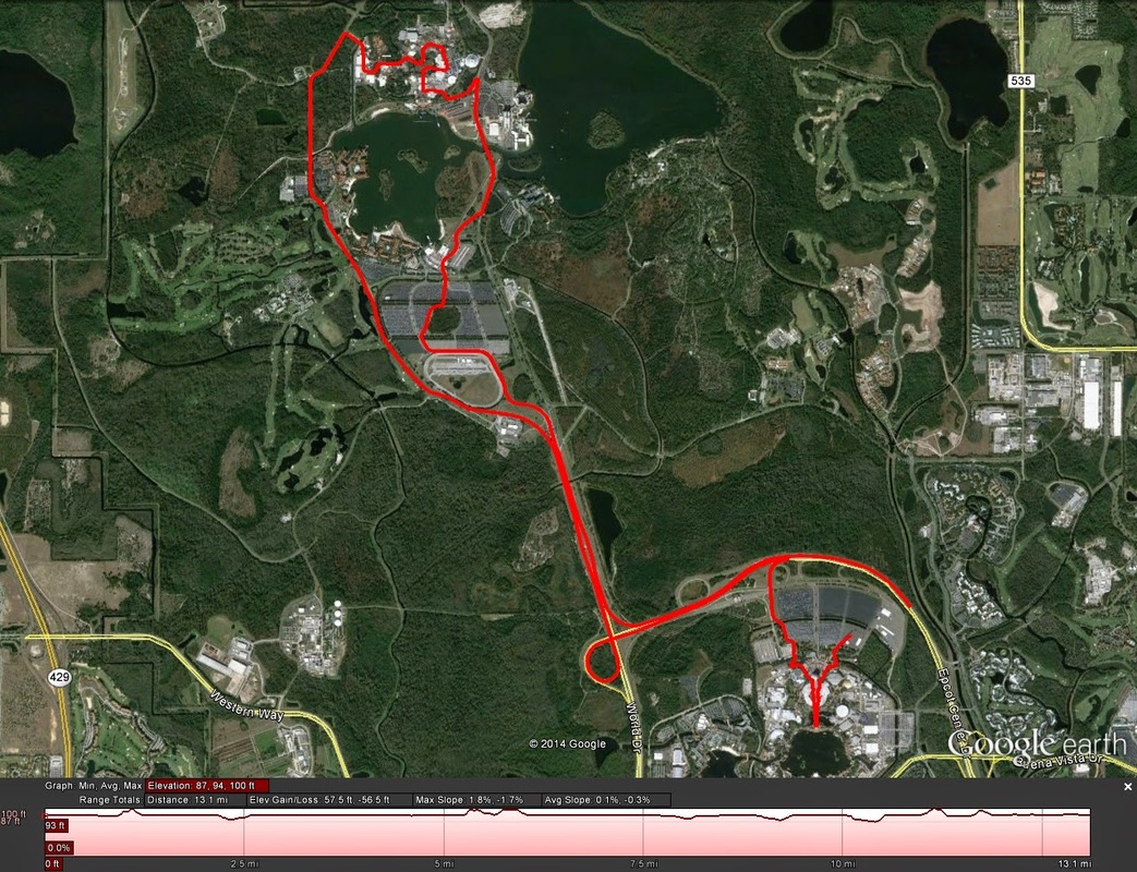 The route, as per Google Earth. There may be a bit of difference around the Richard Petty Driving Experience, but otherwise it should be spot-on. Intro For this course preview specifically, the half-marathon distance will be covered. Maps for the full marathon course, and5k/10k course can be found using the links right here, or at the marathon weekend's official website, which is linked at the top of the page. Official half-marathon map can be found HERE, or at the marathon weekend's official website. Course Basics/Metrics Here are the basics for the 2014 half-marathon route...
Climbs Not a single damned one. Although, climbing up the freeway exits provides a notable incline each time, but they aren't quite open for analysis via Google Earth. And speaking of Google Earth, the elevation shows as completely flat, which is not quite the case -- this is why I gave both a Google Earth (above) and TrainingPeaks (below) screenshots of the maps. 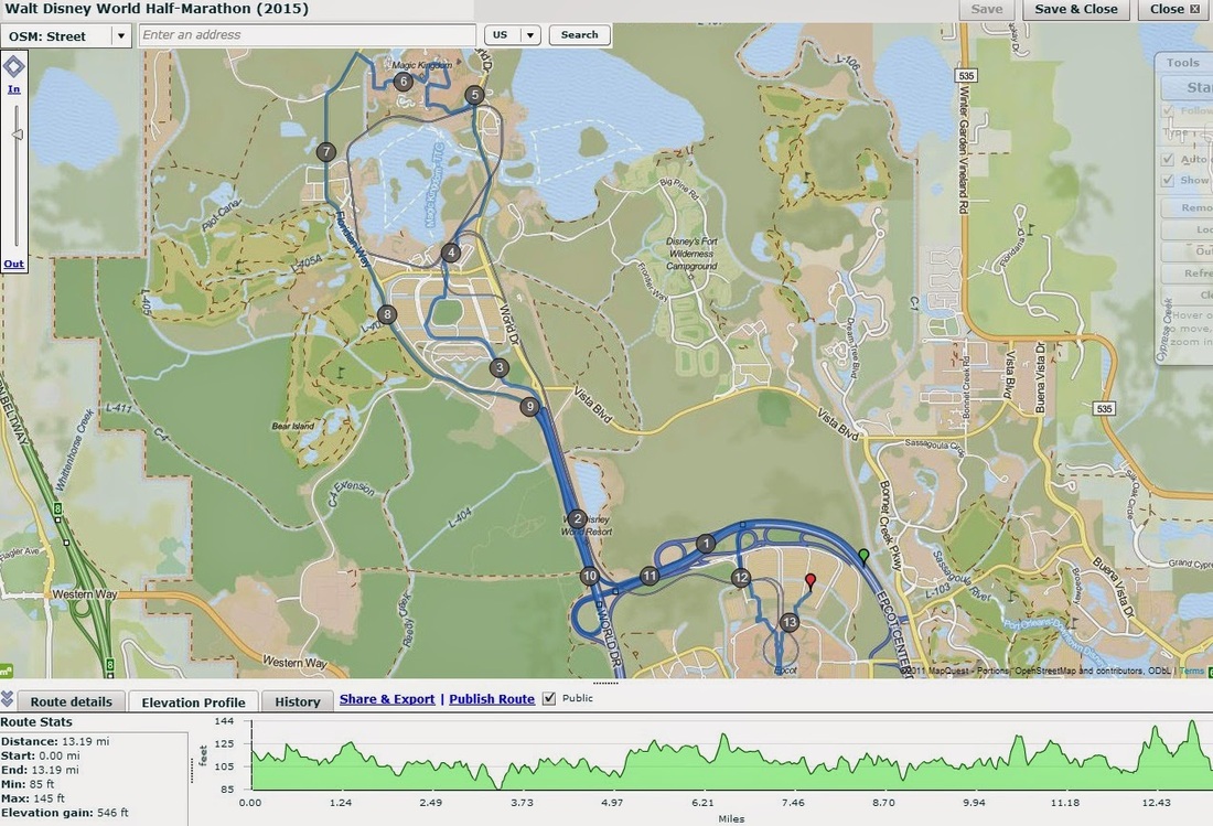 Virtual Run Start Line through 2.5mi: The half-marathon and full marathon routes start in the same place, along Epcot Center Drive, just Northeast of Epcot's parking lots. 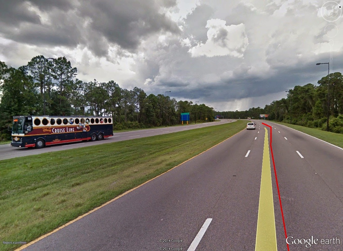 Mile Zero: Approximately where the start line would be. Epcot's parking lots are just beyond the tree line to the left. The first several miles are wide open: no real elevation change, and very little as far as visual stimulation goes. Simply enough, you're just running on highway. Just short of mile marker 1, you see really the only "incline" of the day: a run up a highway exit, transferring from Epcot Center Drive West-bound, to World Drive North-bound. 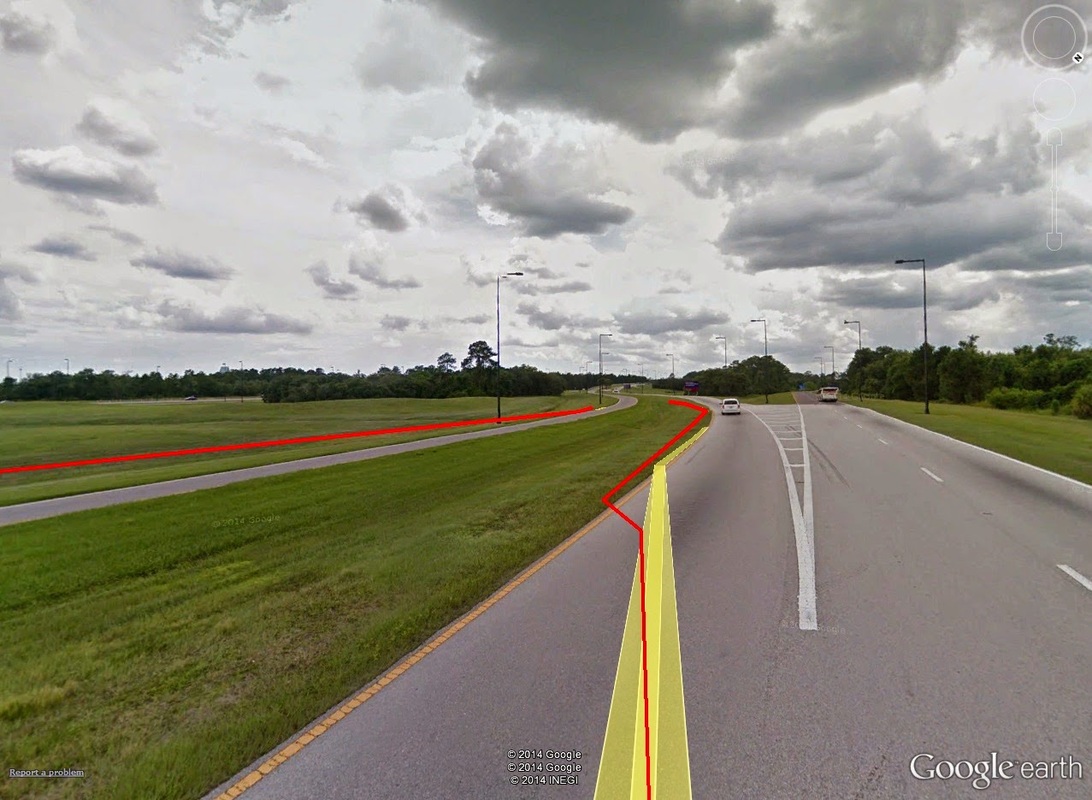 0.9mi: Stay to the left on this exit, and it will swing you North on to World Drive towards the Magic Kingdom. 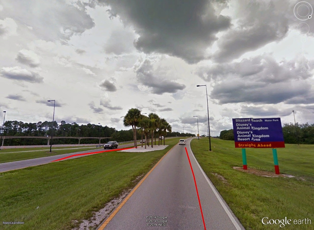 1.3mi: This is about the extent of the course's "hills." Things do get quite narrow on this exit, however. North on World Drive looks very much the same as Epcot Center Drive, save for the occasional Disney World attraction billboard. 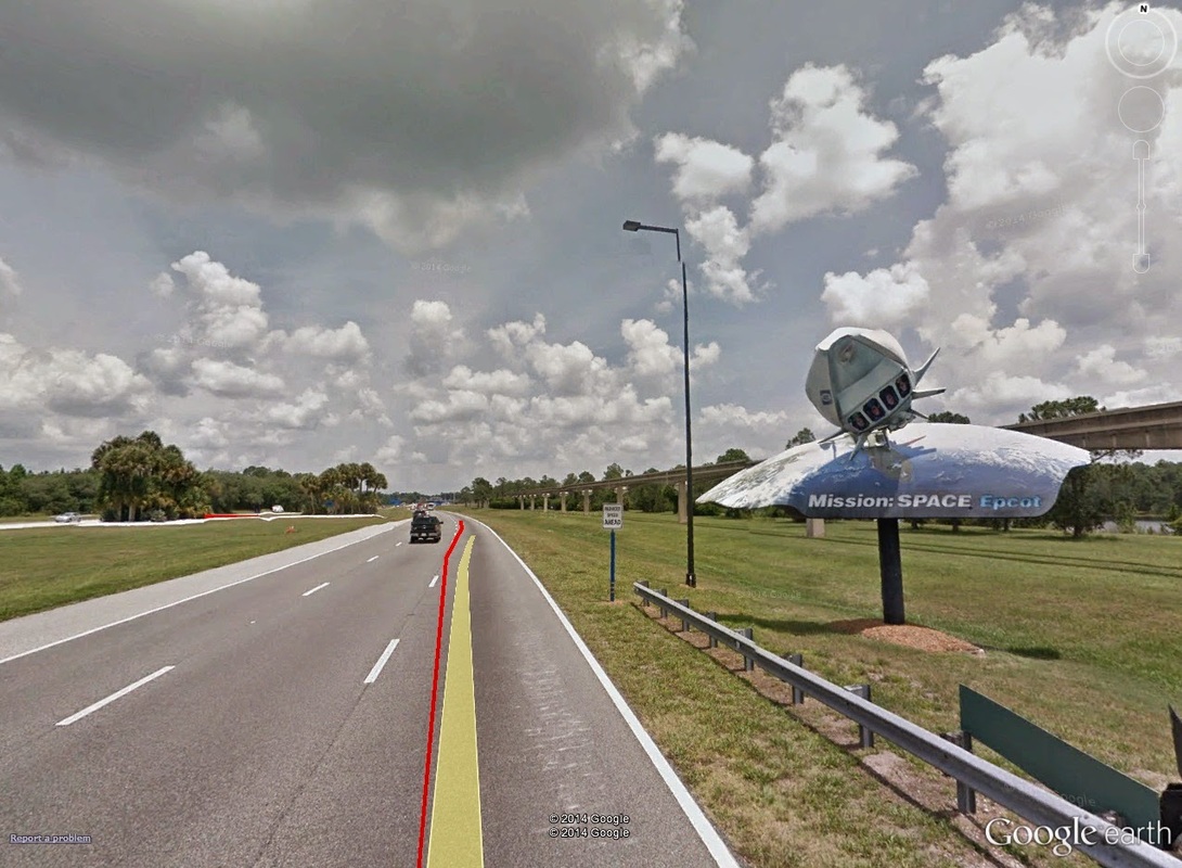 2.0mi: One of the many attraction billboards that adorn the trek along World Drive North. 2.5-3.5mi: It isn't until roughly 2 1/2 miles in that things start happening. At just past mile 2.5, you come to the parking lot entrance for the Magic Kingdom. 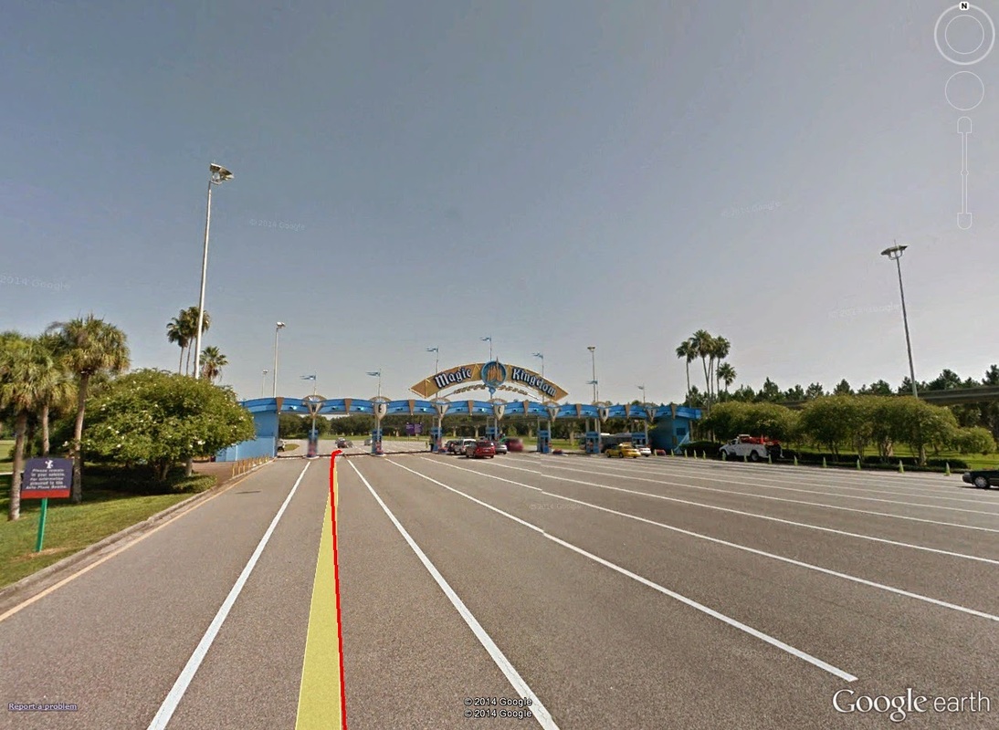 2.6mi: The entrance to the Magic Kingdom, although really it's just the entrance to the parking lot. Passing by the Richard Petty Driving Experience, runners will keep to the right, eventually cutting across the Southwestern-most corner of the parking lot. Even this run-in, from the parking pass booths to the actual parking lot, is...well...long. 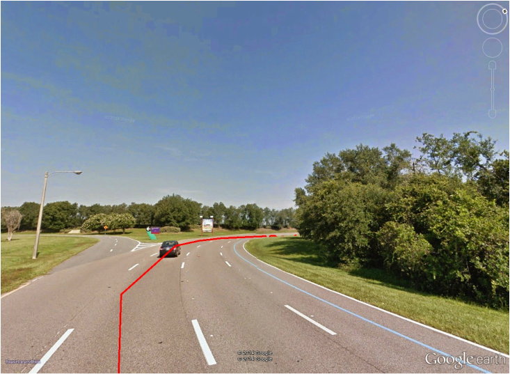 2.85mi: Just short of the 3-mile marker, keep to the right to head in towards the parking lots. 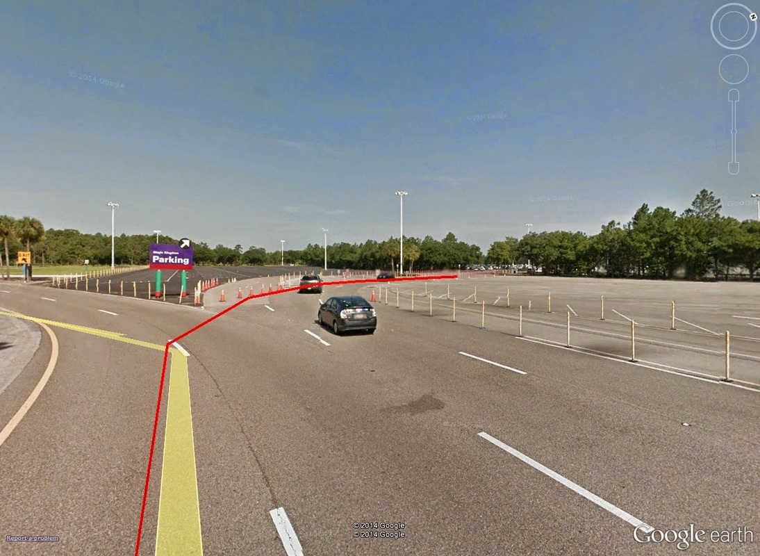 3.35mi: Another half-mile later, you finally get to the actual entrance in to the parking lots. Sheesh. 3.5-5.0mi: Past 3.5 miles, at the North end of the lots -- closest to the ticketing counter -- you run under the bridge that normally is reserved for the parking lot trams. Beyond this bridge, you finally come to the ticketing booths and entrance in to the monorail stations -- but you're not at the actual park yet! 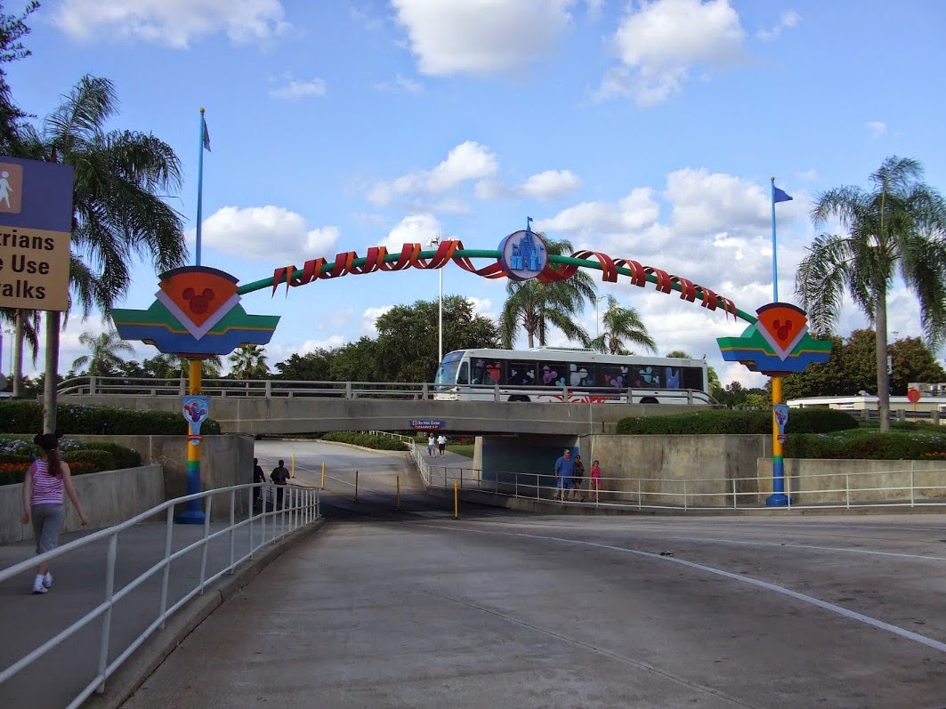 3.85mi: Nearly another half mile later, and runners pass through the tram entrance tunnel to the ticketing booths and monorail station. Passing along the right-most side of the line of ticketing booths, runners continue to keep right, running past the Eastern-most edge of the actual monorail station. This section of road takes runners past a bus station, and back on to World Drive North-bound. 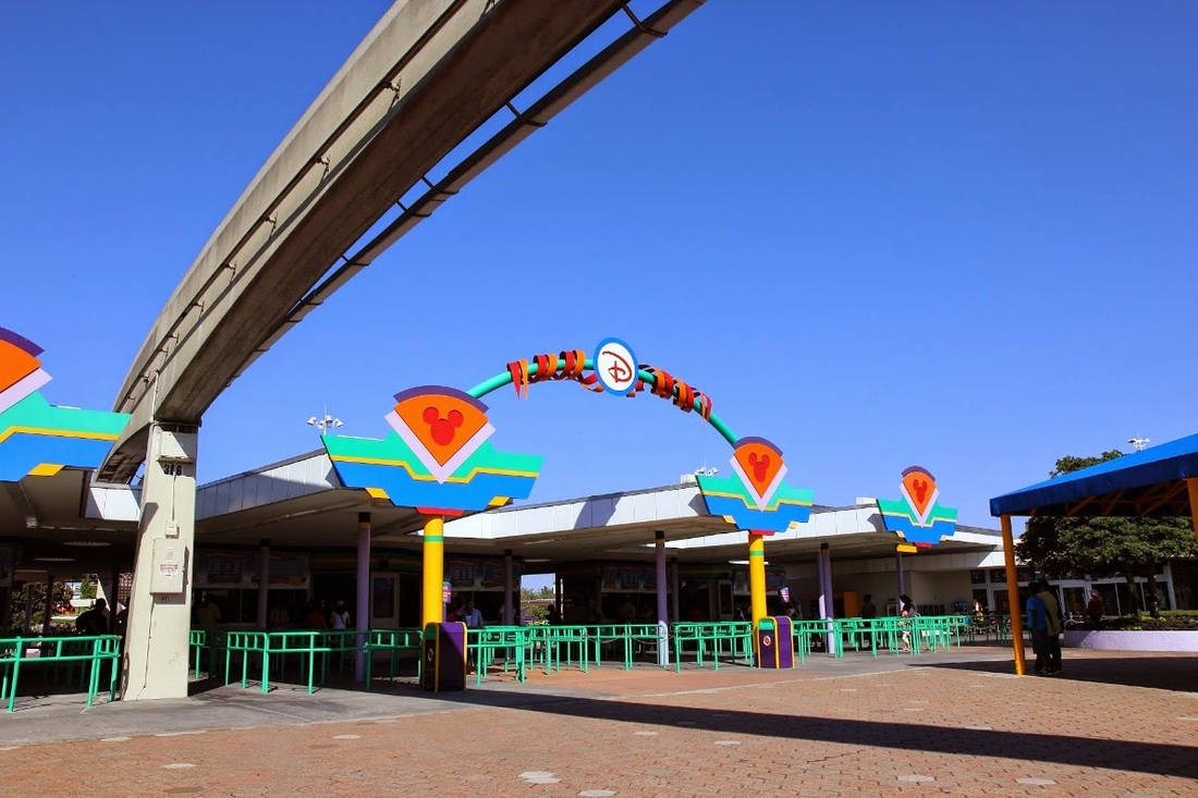 3.85mi: The line of ticketing booths. Runners run through this line, just to the right of that building (merchandise, I believe) (photo credit: Evelio de Feria). 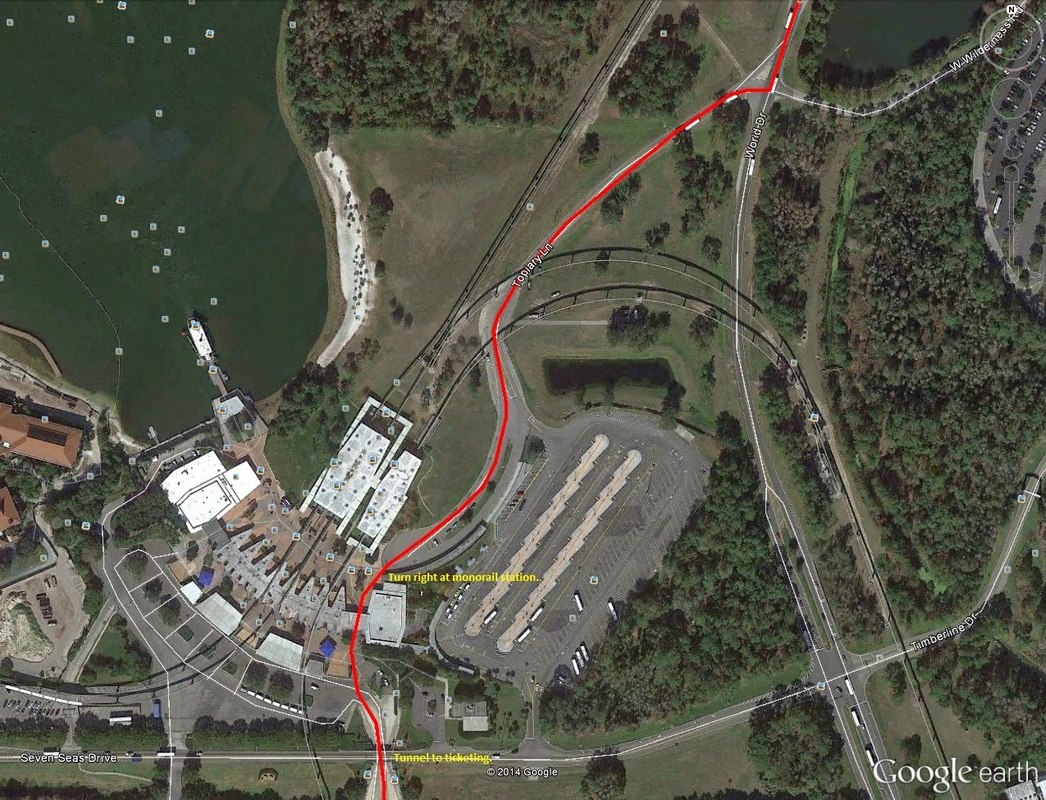 3.85mi-4.25mi: The section between the tram tunnel entrance to the monorail station, the stretch of road past the bus park, and the intersection running back on to World Drive. (Image Credit: Google Earth) Along the Northern trek on World Drive, things become less uneventful as previous. First, runners are hoofing it along the Eastern edge of the Seven Seas Lagoon, a pretty backdrop in its own right. Ahead the massive Disney Contemporary Resort lay on the horizon. This stretch is the final bit before reaching park gates. 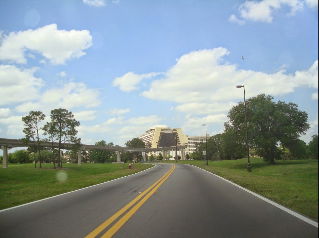 4.25mi: Back north along World Drive, with Disney's Contemporary Resort on the horizon. (Image Credit: Carlos Pichardo) 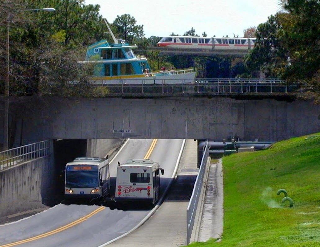 4.5mi: The water bridge under the Seven Seas Lagoon. Yes, UNDER the lagoon. Magic Kingdom, 5.0mi - The final bits of World Drive come at right near mile marker 5. From here, runners will turn left in to a employee/maintenance entrance towards the park. 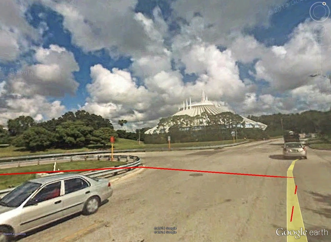 4.95mi: The left-turn off World Drive (red line), with Space Mountain dominating the horizon ahead. Then, a quick quarter-mile along a maintenance lot. At roughly 5.30 miles, finally, you come to a side entrance on to Main Street, USA of the Magic Kingdom. 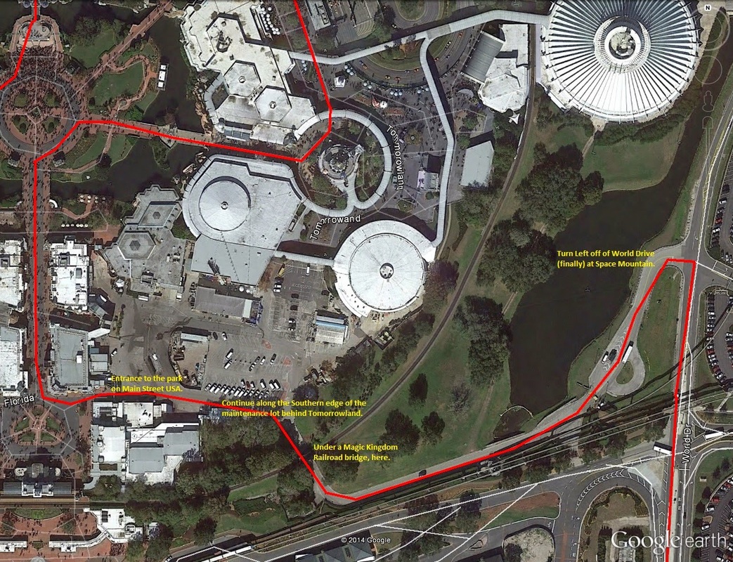 5.00-5.35mi+: The short stretch of road from World Drive to Main Street, USA. The disc-like structure in the upper right-hand corner is Space Mountain. The one in the center is the Carousel of Progress. 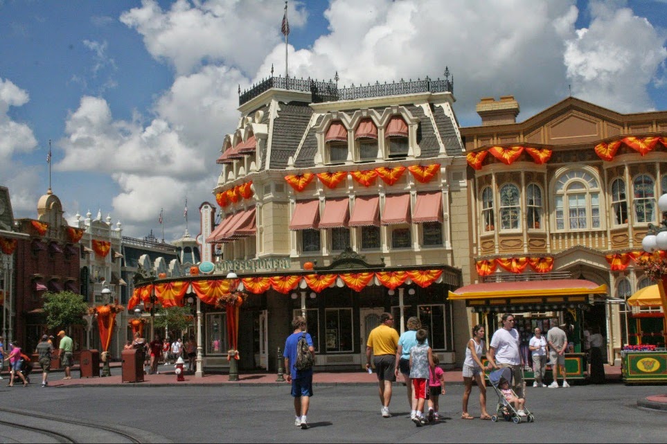 5.20mi: Runners will enter the park through a side entrance at the popular Confectionery store front at the mouth of Main Street, USA in the Magic Kingdom. (photo credit: Scott Hanko) 5.25 miles or so is when you jump on to Main Street, USA, and the first steps on actual Disney park. Runners run straight North on Main Street, USA towards the Walt Disney statue that marks the crossroads of the park. 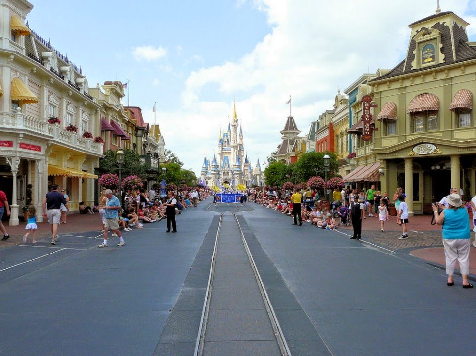 5.25mi: The view straight down Main Street, USA towards Cindarella's Castle. At the Disney statue, barely a tenth of a mile later, runners take a right in to the aptly-themed Tomorrowland section of the park. 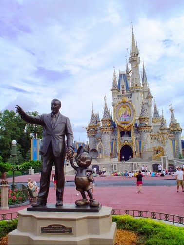 5.35mi: The aforementioned Disney statue. Take a right-hander BEFORE this, heading in to... 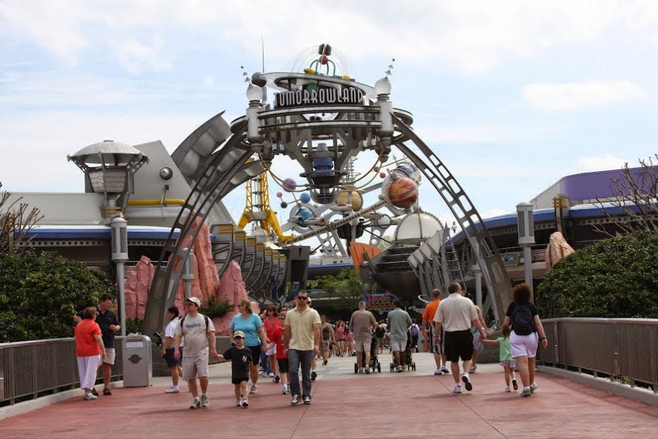 ...Tomorrowland! (and the inspiration for the next George Clooney movie.) (photo credit: Scott Hanko) From here, it's a run through the Eastern and Northeastern sections of the park, first with, of course, Tomorrowland, then Fantasyland, including a bit of the former (or is it still??) Toon Town. In Tomorrowland, participants run past the Monster's, Inc. Laugh Factory before taking a left short of the central pavilion (the one with AstroOrbiter on its rooftop). From there, head along the stretch of walkway past the Tomorrowland Speedway. This runs you in to the Eastern-most section of Fantasyland, marked by the Mad Tea Party ride straight ahead. This section, from the opening of Tomorrowland to the opening of Fantsyland makes up about only 0.15mi, from 5.30 to 5.55 miles in to the race. 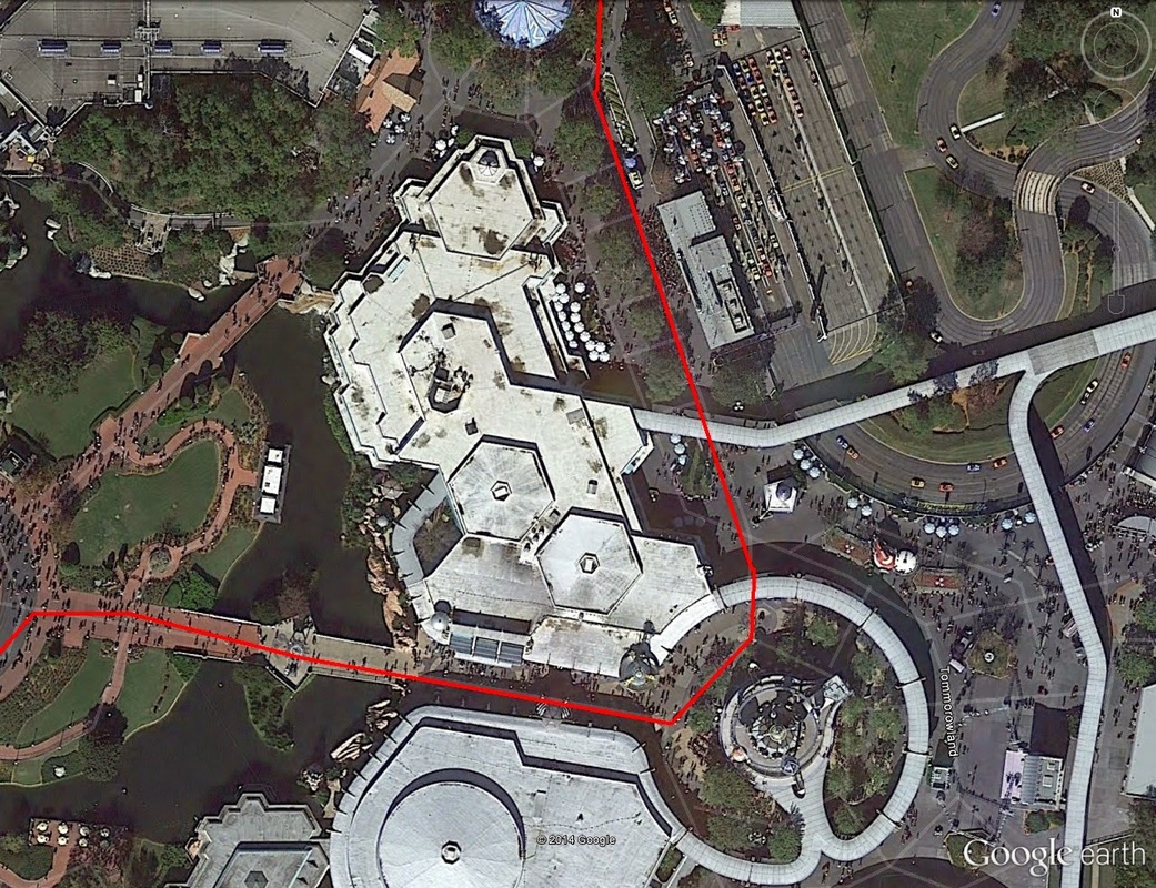 5.30-5.55mi: The trek through Fantasyland. Within Fantasyland, take a right going around the back side of the Mad Tea Party, with the newly-built Cars-themed coaster on your right. This runs you in to Fantasyland's merry-go-round. Again, keep to your left and head straight towards Cindarella's castle. This section of Fantasyland, again is short -- not even two-tenths of a mile -- and runs you up to mile 5.75. 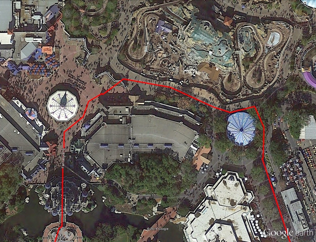 5.55-5.75mi: The run through Fantasyland. 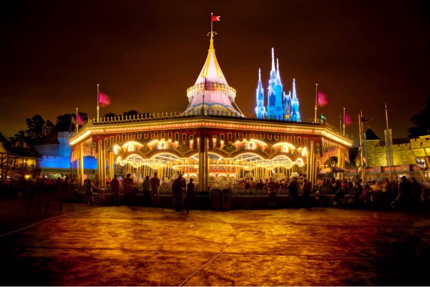 5.70mi: The Fantasyland merry-go-round straight ahead. Stay to your left and you'll head back South though the castle. Finally, at 5.75mi, runners get to hoof it through the famed Cinderella's Castle, the dominant centerpiece for the Magic Kingdom. The run-in will be from the North end of the castle, which is really the back side heading back towards the park entrance. Like before, head towards the Disney statue and take a right just before it, heading in to Adventureland. 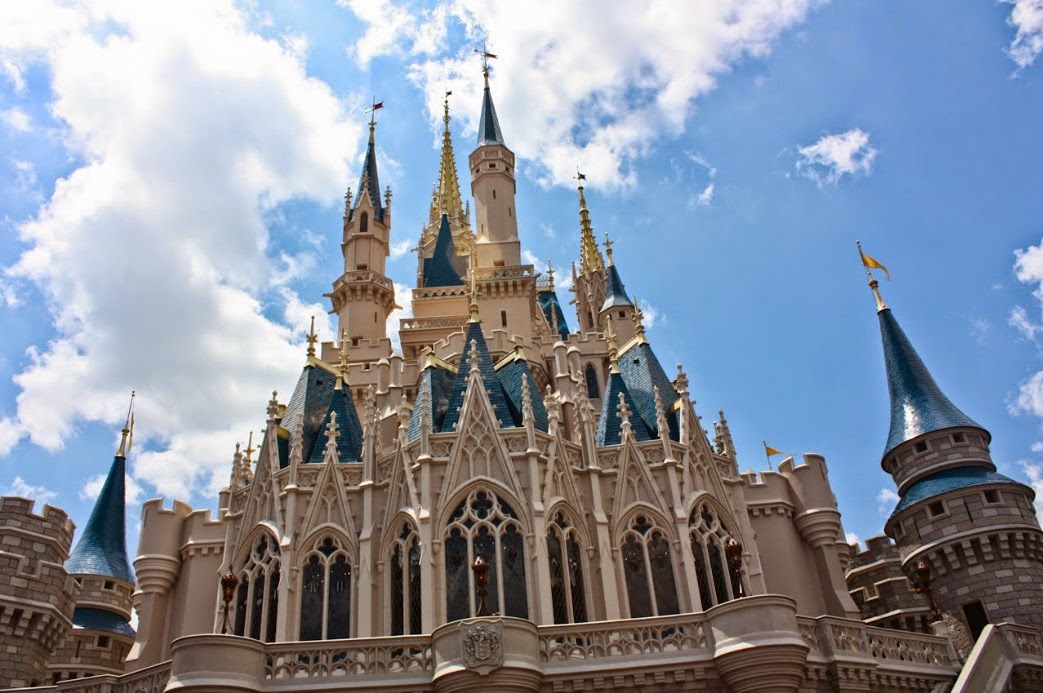 5.75mi: Look up! The view of Cindarella's Castle from its rear entrance (North side). (photo credit: Robert Lam) The stretch of walkway from the Disney statue through to the Western-most edge of Adventureland makes up the final quarter-mile of the Magic Kingdom experience for runners, from miles 5.75 through to 6.10. Mile marker 6 comes right within Liberty Square. 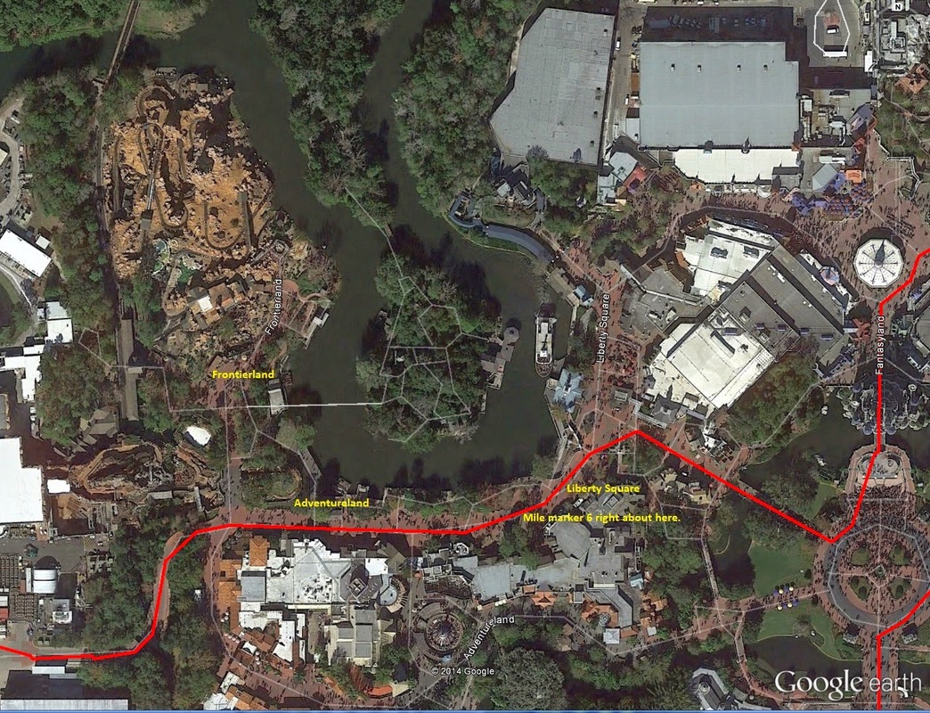 5.75-6.10mi: The course as it runs through Liberty Square, mile marker 6, and Adventureland. 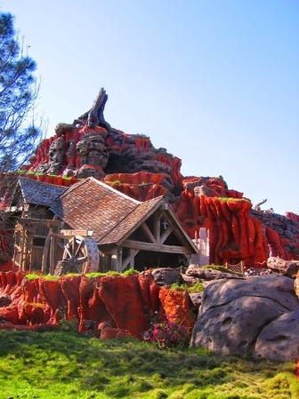 6.05mi: Just past mile marker 6, runners pass by the Southern edge of Frontierland, including the ever-popular Splash Mountain. 6.0-7.0mi: The route exits out a maintenance entrance along the Western edge of the park, right next to Splash Mountain (as a matter of fact both the runner's entrance and exit from the park are where the many Magic Kingdom parades also enter and exit). Pass by the many maintenance and storage buildings against the West side of the park on Caribbean Way, and back on to regular Floridian roads. Don't worry! This boring stretch doesn't last long. 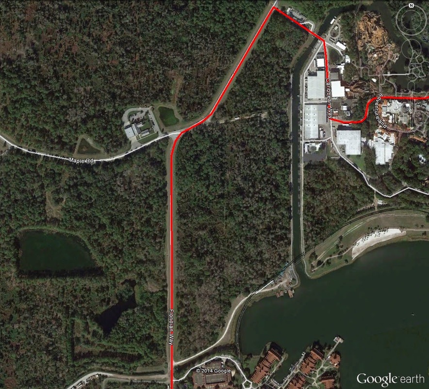 6.0-7.0mi: Mile marker 7 comes at just near the end of this Stretch of road, on Floridian Way. 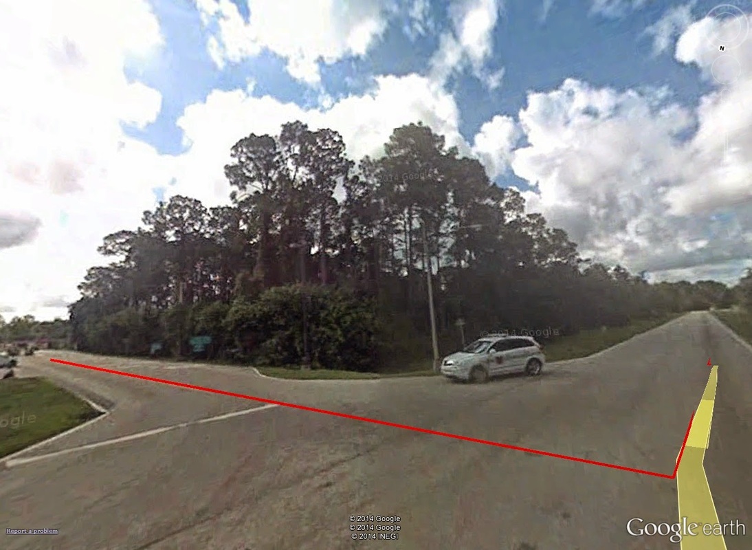 6.35mi: Out of Magic Kingdom's storage area along the Western edge of the park (left side of the image), and on to Floridian Way South-bound (right side of the image). 7.0-8.0mi: This stretch of road along Floridian Way becomes a little more exciting, as the route runs just to the West of the massive Grand Floridian Resort. However, most of this road is lined by trees on both sides, so many of the beautiful views from the road are obstructed. Disney execs reeeeally don't want you to enjoy the scenery unless you are guests of the hotel. 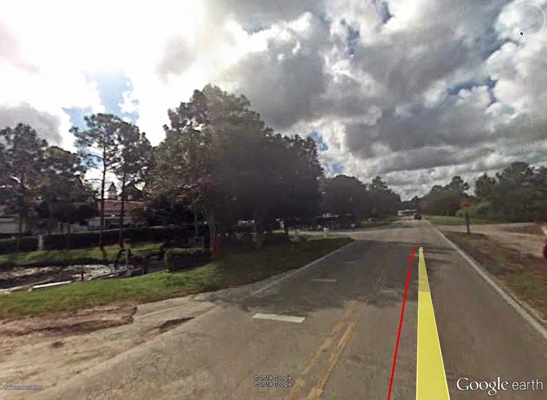 7.0mi: About where mile marker 7 would be. Just beyond the trees on the right, you can just see a bit of the Grand Floridan. 8.00-9.00mi: Now in this bit of course, there seems to be some confusion as to what is the correct route. All of the past half-marathons recorded (by the GPS watches of participants, i.e.) give it one way, yet the "official" course maps on the runDisney website have it another way. I'll give you both. Regardless of which is correct, the conditions are the same: flat. The only real difference is that the past-reported route runs to the south of the Richard Petty Driving Experience track, and the future-planned route (reported by runDisney) runs back through the parking lot and to the North of the track (basically, past mile 8, the same way out the way you came in). Additionally, near the end of this section of road -- about mile marker 9 -- is where full-marathoners break away from the half-marthoners. 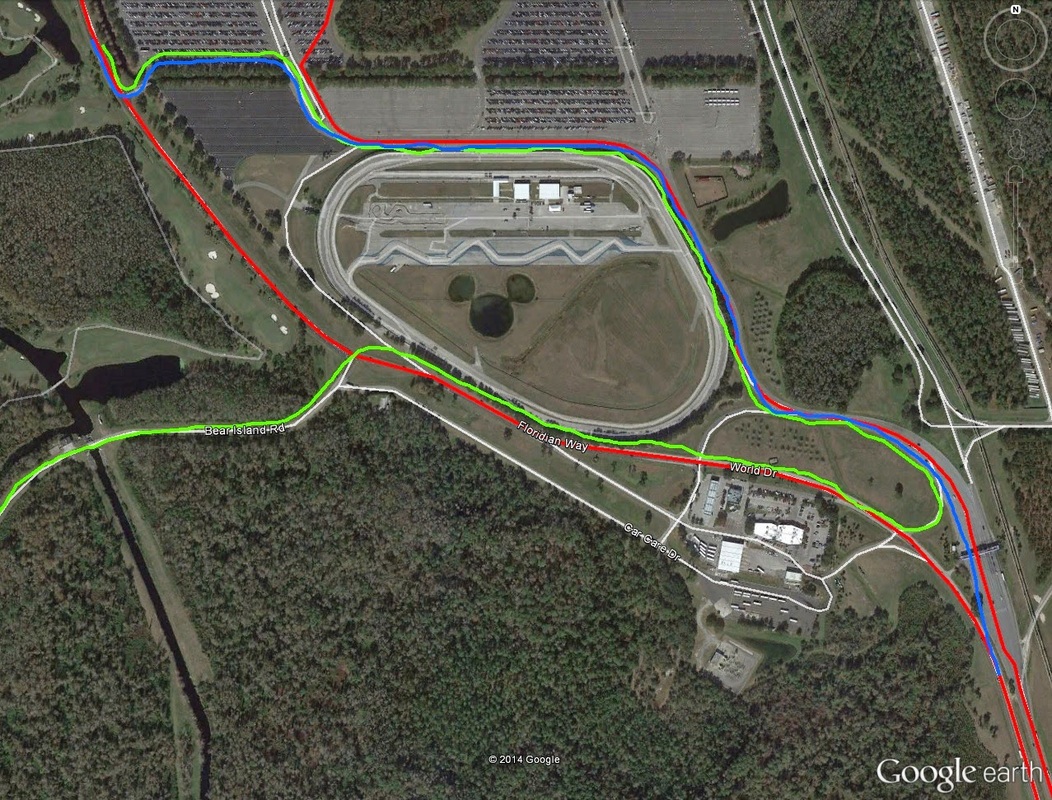 8.0-9.0mi: Excuse my freehand (blue and green). The route in red represents the most oft-reported half-marathon route by past participants. The blue represents the planned half-marathon route (at least, planned for 2014) as reported by the runDisney website. The green is also via runDisney, but represents the full marathon route. 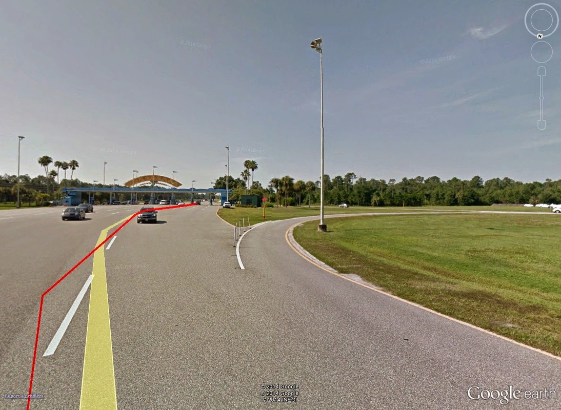 9.0mi: If the race route posted on the runDisney site is correct, half-marathoners continue straight back through the entrance (red line), and full-marathoners take the right-hand exit pictured. 9.0-12.0: Remember that boring highway you ran at the beginning of the race? It's time to do it again. Past the Magic Kingdom parking booths -- and mile marker 9 just beyond it -- it's the same stretch of World Way, this time Southbound back towards Epcot. Again, nothing really remarkable, until the exit back on to Epcot Center Drive, which, again, gives really the only incline seen on-route.  10.0mi: About where mile marker 10 would be is the bridge exit back on to Epcot Center Drive. 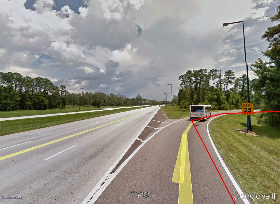 10.2mi: Stay to the right to exit back on to Epcot Center Drive. What little incline you see here -- that's pretty much it. The run-in would seem the same as run-out, but luckily, for the final miles, it isn't. A quick switch-back on Epcot Center Drive puts runners in to Epcot's main lot, headed straight on in to the park. Surprisingly, from this switchback, and along the Western edge of the main lots, is nearly a mile long and more before reaching the first stretches of park. 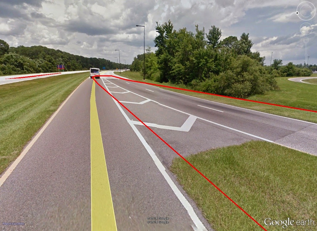 10.5mi: A quick switch-back on Epcot Center Drive. This will take you in to the Western-most portion of Epcot's main lots. Epcot Center, 12.0mi to Finish: Mile 12 comes just as runners are exiting the car park and in to the park's main bus drop-off area. 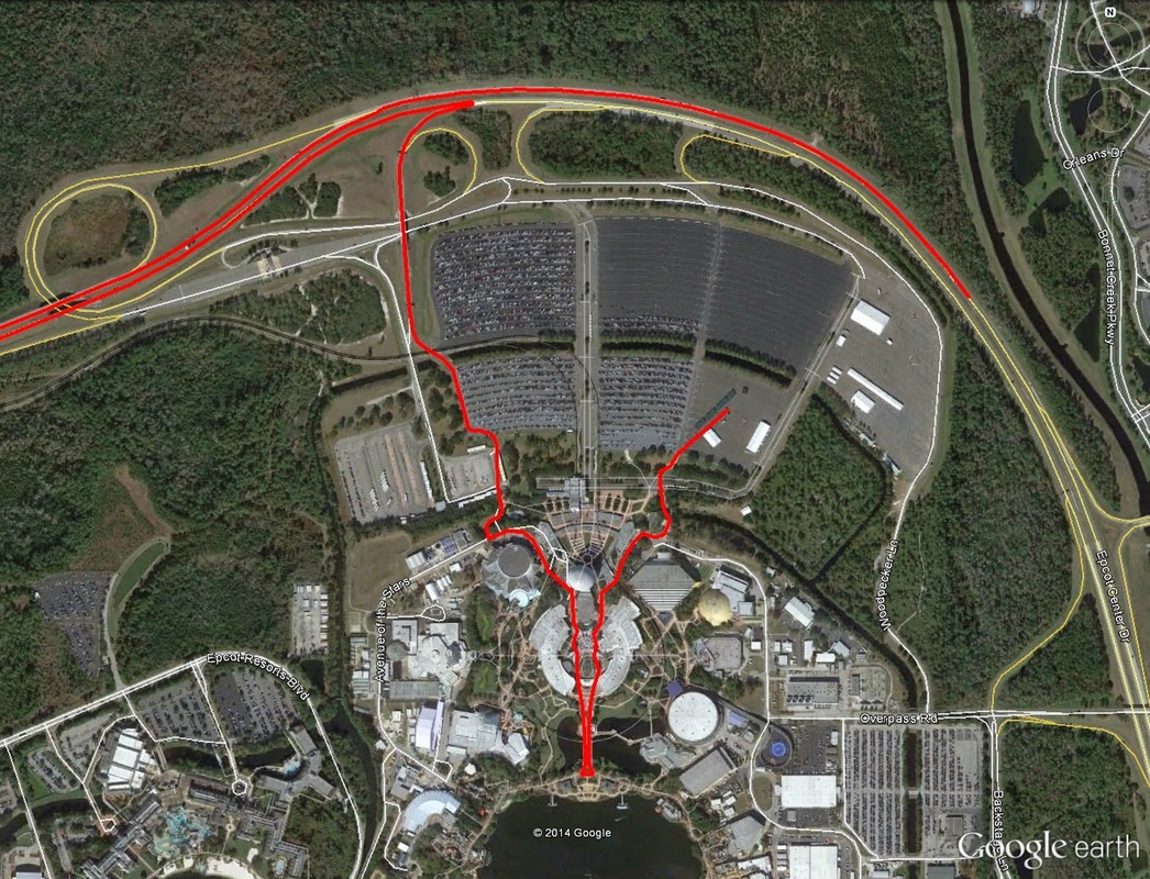 10.4-13.1mi: The final bits of route, through Epcot park. Runners enter on to the park grounds via the Southwestern-most corner of the car park, and then along the Eastern-most edge of the bus drop-off area. 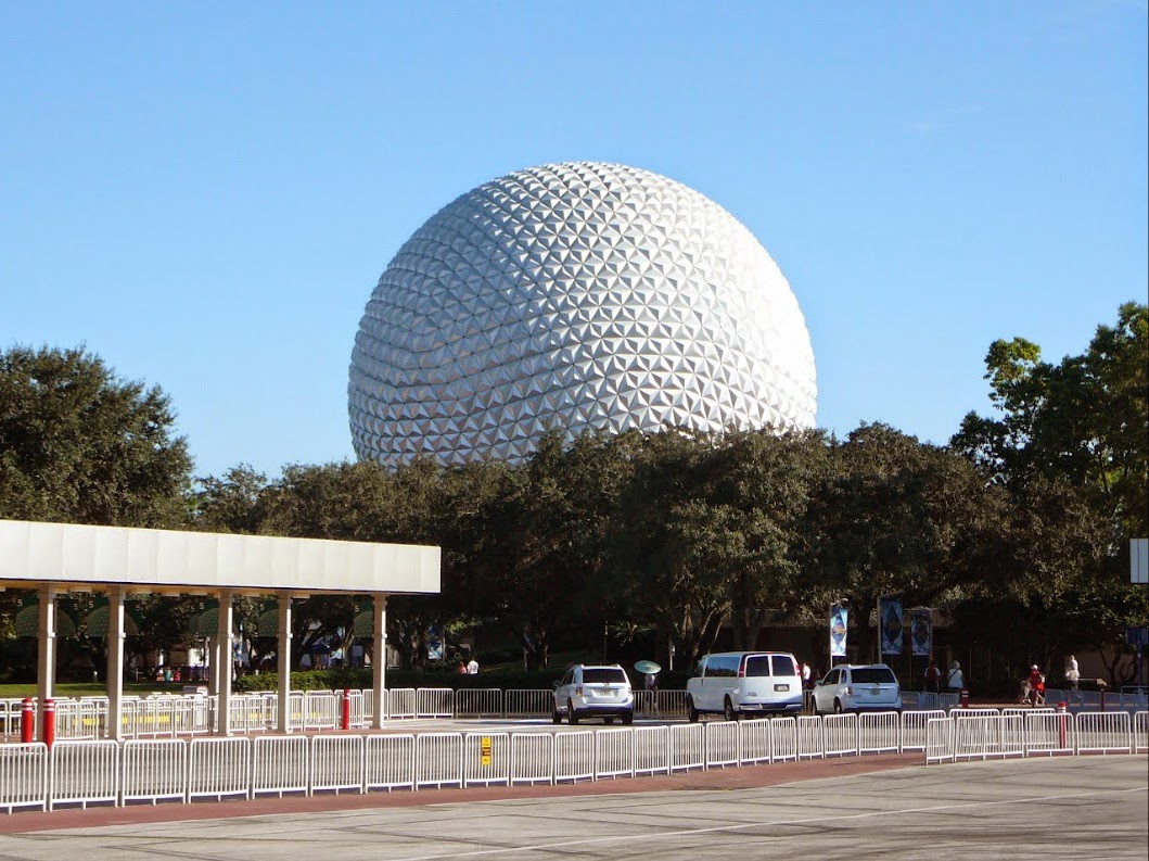 12.0mi: About the location of mile marker 12, at the Eastern-most edge of the bus drop-off area, after just exiting the car park. The central attraction, Spaceship Earth, is clearly visible from here. At about 12 and a quarter miles, runners finally get in to the main guts of the park, in through the back side of The Seas (with Nemo) attraction. From there, just head for the "giant golf ball" (Spaceship Earth). Once there, take a right through the main plaza around the fountain. Given that it is winter, presumably EPCOT will still have their winter season display up on the "bridge" in to the World Showcase. You won't be running through the World Showcase itself, though! (a damn shame) Instead, turn around at the first garden island as you come off the bridge (where the "Holiday tree" would be, if their winter decorations are still up) and head back towards Spaceship Earth. The run back out of EPCOT is essentially a reversal of the run in, with the exception that runners will be heading out on the opposite site of Spaceship Earth (east side instead of west side). A brief trot through an employee lot will spit you out in to the main EPCOT parking lot (southeastern-most corner). Suddenly...THE FINISH LINE! Not even a tenth of a mile after emerging through the trees form the employee lot, the finish line appears. It's as simple as that. Next stop is the actual weekend, just over a month away! I will update when possible on the trek in to Orlando, around the Expo, and for the race itself.
Until then... ...well, you know. -tds ~~__o _-/<,_ @/ @ |
