|
2015 Heartland Heat Triathlon Saturday, September 5th, 2015 @ 8:00am Tiffany Hills Park 9400 N. Congress Kansas City, Missouri
Another pool-swim triathlon! And a good one to cap off the season. Yeah, a September start date risks a chilly swim; but then again, in the Midwest, a September start date could also mean pushing 90 degrees on the run (and, actually, the latter sounds more likely, given the forecast). In 2014, this one got cancelled, so I didn't get the chance to race the route. So this preview will be as much a preview for me as everyone else. ONWARD! Registration Online Registration is closed as of publication, but is available during packet pick-up (see address below) as well as onsite. Sorry about the delay on this bit! Packet Pick-Up Thursday, September 3rd, 2015 Friday, September 4th, 2015 4:00-8:00pm Kansas City North Community Center 3930 NE Antioch Kansas City, Missouri DAY-OF PACKET PICK-UP IS AVAILABLE AT THE RACE SITE Once again, not familiar enough with the race to give advice about packet pick-up. Two days of availability is nice. And if all else fails, you can always pick it up on race day. Location of the Kansas City North Community Center is mapped below. Race Day Parking Tiffany Hills Park 9400 N. Congress Kansas City, Missouri Two locations for parking. Tiffany Hills park is where the race is, with two parking lots available: one on the East side of the park just off N Congress, and one at the Southwest corner of the park just off NW Old Tiffany Springs Rd. The main parking is the East entrance parking. According to the official Athlete guide, athletes are encouraged to arrive early, between 5:30 and 6:15 to allow plenty of parking time. Here's the main parking lot mapped... The overflow parking, as well as the parking lot designated for spectators is the Southwest lot off NW Old Tiffany Springs. Here's it's location on the map... Additional Race Day Information
Course Previews Official maps weren't working for me at their website. They are available in the Athlete Guide, but I like to see them mapped out with an activity tracker website, including profile. Here they are via my MapMyRun profile...
Let's break it down by sport, yeah? Transition Okay, not technically a sport. But, really, anyone who's experience a transition would agree: it should be considered as such. A tricky bit here: The Athlete Guide gives no indication about the exact location of transition (a big drawback in my book). But, given the other information included, I can surmise as to the location of transition. For example, in the photo I included in the Swim Leg section, the north side of the parking lot shown (where the blacktop gets dark) is noted in the Athlete guide as dedicated to parking. Given the other information provided, I would put the approximate location to be in the box I outlined in blue (excuse my artistic prowess). But it's just that: an approximation. That said, from here on out, regardless of leg, my notes about the locations of transition-outs are only an estimation. My apologies for any differences come race day. Swim Leg Here are the basics for the swim leg...
Tiffany Springs Aquatic Center has eight lap lanes, each at 50m in length. Given the distance (400m), that means each lane will have to be LENGTHED (READ: NOT LAPPED FULLY) to reach the 400m distance. This means you start in lane 1, swim to the opposite end, THEN duck under the rope to lane 2, swim to the opposite end, duck under the rope to lane 3, and so on, until all 8 lanes are LENGTHED completely. This might be different then some pool swims you have done, as sometimes the length is 25m, thus forcing the requirement of lapping the entire lane (down AND back). THIS IS NOT THAT KIND OF SWIM. Of the serpentine-style swims there are, this is the best type. This means that, if you don't pass (or aren't passed by another), you never have to swim past another person in the same lane. The water can get a fair bit dicey when this happens. The serpentine-style lapping is illustrated in the below map, as well as the ESTIMATED route (ugly red line with triangles) to transition (ugly blue box). 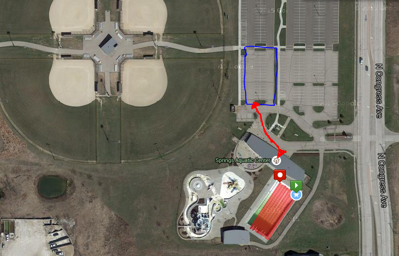 Bike Leg Here are the bike leg basics...
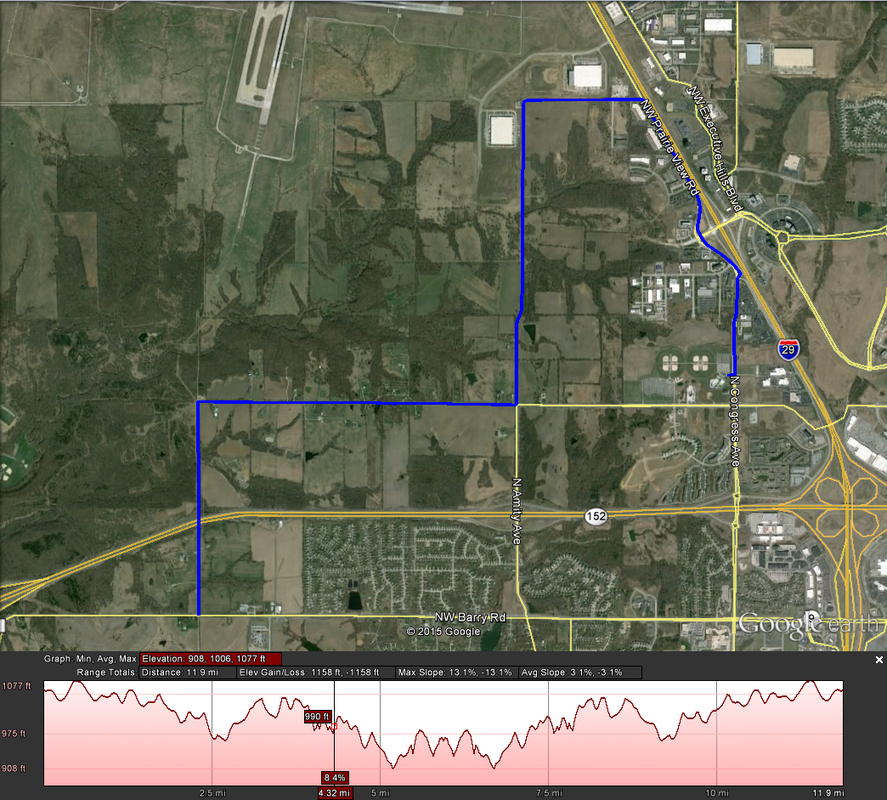 Pay special attention to the overall elevation gain: It's not anything to scoff at. Though the number of significant climbs en-route (2, technically) is a small number, the number of overall undulations is significant (check out that elevation profile!). In fact, because all the climbs are so similar, I won't even cover the specific climbs in detail: there's one of 80 feet at 2.7mi, and one of 70 feet at 6.7mi in to the bike. The ride out of transition is, presumably, out the East side of the parking lot. From there, it's a simple out-and-back job. The overall profile is downhill for the first half and uphill for the last half, although I doubt it'll be too noticeable through the pain of frequent uphill-downhill-uphill. Also note the wind for the day -- the openness of the route will leave riders effected a bit by it. Run Leg The basics for the run route...
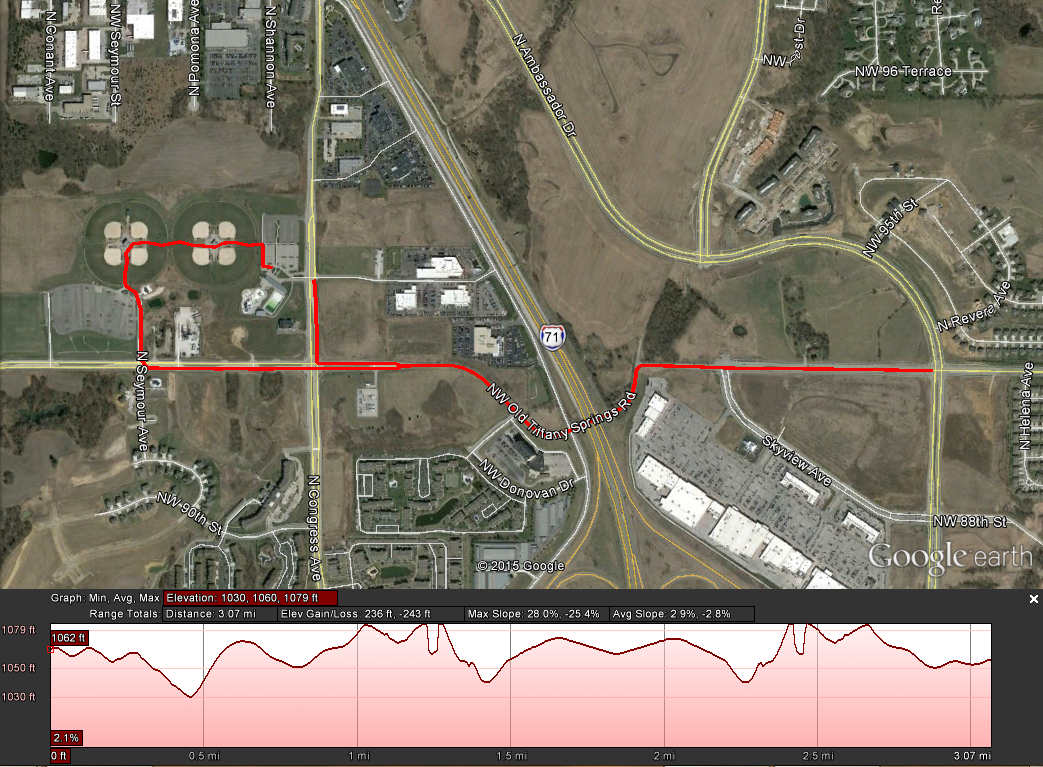 This one is a touch different, with the run heading Westbound from the transition area (TOWARD the baseball fields). You get a nice run through the ball fields before exiting out the Southwest parking lot (the same mentioned for overflow parking above) on to NW Old Tiffany Springs Road. Then, again, it's an out-and-back until N Congress Road. Take a right-hander heading North (this time headed towards where you exited for the bike from the East parking lot). The finish line is (likely) just outside the parking lot on Congress.
There are some undulations to the course similar to the bike route. However, there is one notable climb: the exit out of the Southwestern parking lot gives a brief quarter-mile climb up about 45 feet. It's a touch on the steep side, so be expecting that. By no means a flat route at 236 feet of climbing for just under a 5k. And that's it! It is sprint-distance, but it's not the easiest of courses (although the venue is pretty). Get out there and enjoy it! Keep R/B/S-ing. -tds ~~__o _-/<,_ @/ @
0 Comments
|
