|
2015 Heartland Heat Triathlon Saturday, September 5th, 2015 @ 8:00am Tiffany Hills Park 9400 N. Congress Kansas City, Missouri
Another pool-swim triathlon! And a good one to cap off the season. Yeah, a September start date risks a chilly swim; but then again, in the Midwest, a September start date could also mean pushing 90 degrees on the run (and, actually, the latter sounds more likely, given the forecast). In 2014, this one got cancelled, so I didn't get the chance to race the route. So this preview will be as much a preview for me as everyone else. ONWARD! Registration Online Registration is closed as of publication, but is available during packet pick-up (see address below) as well as onsite. Sorry about the delay on this bit! Packet Pick-Up Thursday, September 3rd, 2015 Friday, September 4th, 2015 4:00-8:00pm Kansas City North Community Center 3930 NE Antioch Kansas City, Missouri DAY-OF PACKET PICK-UP IS AVAILABLE AT THE RACE SITE Once again, not familiar enough with the race to give advice about packet pick-up. Two days of availability is nice. And if all else fails, you can always pick it up on race day. Location of the Kansas City North Community Center is mapped below. Race Day Parking Tiffany Hills Park 9400 N. Congress Kansas City, Missouri Two locations for parking. Tiffany Hills park is where the race is, with two parking lots available: one on the East side of the park just off N Congress, and one at the Southwest corner of the park just off NW Old Tiffany Springs Rd. The main parking is the East entrance parking. According to the official Athlete guide, athletes are encouraged to arrive early, between 5:30 and 6:15 to allow plenty of parking time. Here's the main parking lot mapped... The overflow parking, as well as the parking lot designated for spectators is the Southwest lot off NW Old Tiffany Springs. Here's it's location on the map... Additional Race Day Information
Course Previews Official maps weren't working for me at their website. They are available in the Athlete Guide, but I like to see them mapped out with an activity tracker website, including profile. Here they are via my MapMyRun profile...
Let's break it down by sport, yeah? Transition Okay, not technically a sport. But, really, anyone who's experience a transition would agree: it should be considered as such. A tricky bit here: The Athlete Guide gives no indication about the exact location of transition (a big drawback in my book). But, given the other information included, I can surmise as to the location of transition. For example, in the photo I included in the Swim Leg section, the north side of the parking lot shown (where the blacktop gets dark) is noted in the Athlete guide as dedicated to parking. Given the other information provided, I would put the approximate location to be in the box I outlined in blue (excuse my artistic prowess). But it's just that: an approximation. That said, from here on out, regardless of leg, my notes about the locations of transition-outs are only an estimation. My apologies for any differences come race day. Swim Leg Here are the basics for the swim leg...
Tiffany Springs Aquatic Center has eight lap lanes, each at 50m in length. Given the distance (400m), that means each lane will have to be LENGTHED (READ: NOT LAPPED FULLY) to reach the 400m distance. This means you start in lane 1, swim to the opposite end, THEN duck under the rope to lane 2, swim to the opposite end, duck under the rope to lane 3, and so on, until all 8 lanes are LENGTHED completely. This might be different then some pool swims you have done, as sometimes the length is 25m, thus forcing the requirement of lapping the entire lane (down AND back). THIS IS NOT THAT KIND OF SWIM. Of the serpentine-style swims there are, this is the best type. This means that, if you don't pass (or aren't passed by another), you never have to swim past another person in the same lane. The water can get a fair bit dicey when this happens. The serpentine-style lapping is illustrated in the below map, as well as the ESTIMATED route (ugly red line with triangles) to transition (ugly blue box). 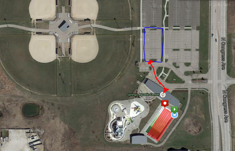 Bike Leg Here are the bike leg basics...
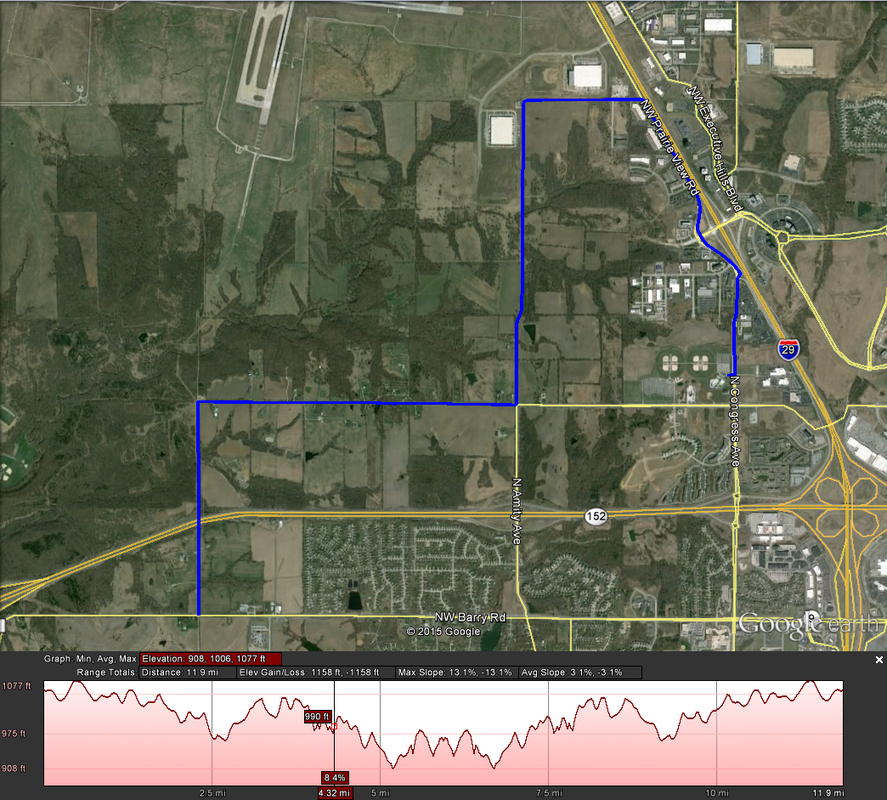 Pay special attention to the overall elevation gain: It's not anything to scoff at. Though the number of significant climbs en-route (2, technically) is a small number, the number of overall undulations is significant (check out that elevation profile!). In fact, because all the climbs are so similar, I won't even cover the specific climbs in detail: there's one of 80 feet at 2.7mi, and one of 70 feet at 6.7mi in to the bike. The ride out of transition is, presumably, out the East side of the parking lot. From there, it's a simple out-and-back job. The overall profile is downhill for the first half and uphill for the last half, although I doubt it'll be too noticeable through the pain of frequent uphill-downhill-uphill. Also note the wind for the day -- the openness of the route will leave riders effected a bit by it. Run Leg The basics for the run route...
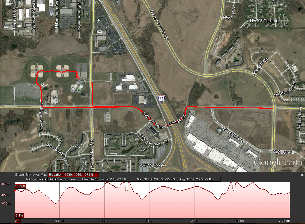 This one is a touch different, with the run heading Westbound from the transition area (TOWARD the baseball fields). You get a nice run through the ball fields before exiting out the Southwest parking lot (the same mentioned for overflow parking above) on to NW Old Tiffany Springs Road. Then, again, it's an out-and-back until N Congress Road. Take a right-hander heading North (this time headed towards where you exited for the bike from the East parking lot). The finish line is (likely) just outside the parking lot on Congress.
There are some undulations to the course similar to the bike route. However, there is one notable climb: the exit out of the Southwestern parking lot gives a brief quarter-mile climb up about 45 feet. It's a touch on the steep side, so be expecting that. By no means a flat route at 236 feet of climbing for just under a 5k. And that's it! It is sprint-distance, but it's not the easiest of courses (although the venue is pretty). Get out there and enjoy it! Keep R/B/S-ing. -tds ~~__o _-/<,_ @/ @
0 Comments
NOTE: The location of the entrance on to the base has been updated with the correct information: 4th & Metropolitan 2015 CGSC Triathlon Saturday, May 2nd, 2015 @ 8:00am Fort Leavenworth, Kansas
In terms of pool-swim triathlons (or really, any area triathlon), this is one of my favorites. No, it's not the longest, or hardest, or stacked with the utmost elite, but the charm, awesome race route, and incredible volunteers and support staff make this a worthy addition. The CGSC Triathlon serves as another fantastic warm-up race to the USAT Duathlon National Championships coming up in just over a month's time. Although, admittedly, it didn't take the need for additional practice to want to do this one again -- I had an absolute blast in 2014, and was quick to register the second it became available. Packet Pick-Up Friday, May 1st, 4:00-6:00pm Frontier Conference Center 350 Biddle Blvd. Fort Leavenworth, Kansas 66027 (also available race morning, inside Harney Gym) The only pre-race packet pick-up is the day before, for two hours between 4 and 6pm, at the Frontier Conference Center on Fort property. OF IMPORTANT NOTICE, you will have to check in through the Fort's eastern entrance at 4th and Metropolitan Avenue, which includes a car search (unless you have a CAC card or DD Form 2). For this reason, the majority of participants end up picking up packets on race day, which is available in Harney Gym, in the basketball courts next to the swimming area (there will be signs). ANOTHER NOTE OF IMPORTANCE, if you plan on picking up your packet race day, you still do have to check in at the main entrance. And with race day traffic, lines to get on Fort property are likely to be long. Expect upwards of a 30-45 minute wait to get on campus, and plan accordingly. EXACT location of the main Fort check-in is mapped below. Fort Check-In As noted, getting on Fort property is the biggest headache. For those that participated last year, Leavenworth Triathlon Club (who helps host the event) notes that getting on to Fort Leavenworth has changed this year. "For those participants that DO NOT have a Military issued Identification Card (CAC or DD Form 2), please arrive 20-30 minutes earlier than normal on Saturday morning because you will have to go through a background check over at the temporary facility located next to the National Guard / Mission Command Training Complex (north of the intersection of 4th Street and Metropolitan Ave). Please ensure everyone in the vehicle has an approved photo ID with them (such as a driver’s license). For those CCP holders, remember concealed carry is NOT allowed on Federal Property." Of note, last year we checked in at the main entrance (noted in the blurb above), which was actually located at SEVENTH and Metropolitan. FOURTH and Metropolitan is the side entrance, which is new for this year. Good news is you pass 4th and Metropolitan on the way to 7th and Metropolitan. So, if they've switched to using the side entrance, hopefully that's obvious when approaching campus. Race Day Parking Primary parking is located west of the Dining Facility on campus, at Iowa and Monroe (see map provided below). Additional lots are located at the Commissary. The parking lot north of transition is open, but only to volunteers. Plus, it will close down (no entrance or exits) for the entire duration of the triathlon. Exact location of primary parking is noted below... Race Day Amenities
Course Preview 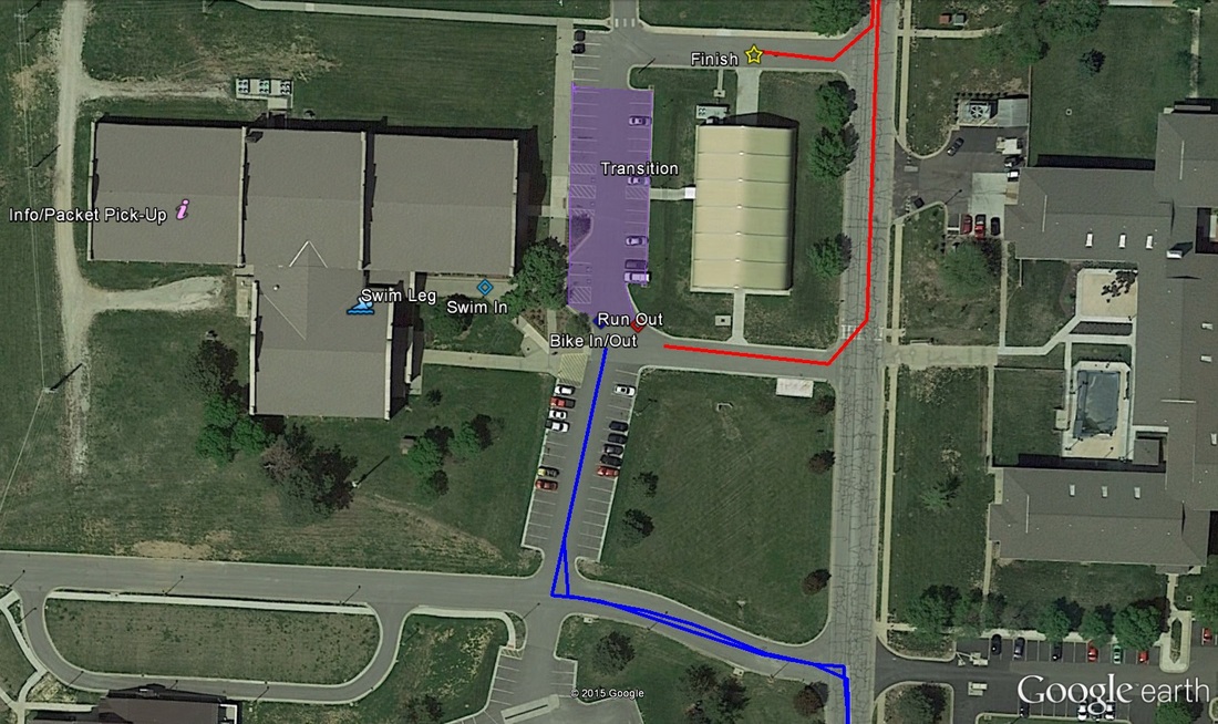 Transition Transition is located to the east of Harney Gymnasium, just off the northwest corner of Monroe and 4th. All entrances/exits to and from transition happen on the south side of the transition corral. The corral setup is first-come-first-serve, and not reserved whatsoever, so come early and set up early! Entrance from the swim happens at the southwestern-most corner of transition. Bike entrance and exit are the same spot, in the middle of the southern edge of transition. Exit to the run course is at the southeaster-most corner of transition. If the same as last year, a water station is located right at run-out. Swim Leg This triathlon features an indoor pool swim of 200 yards in length -- or just 183 meters if you wanna be all metric -- quite short. Athletes will first gather at the basketball courts inside Harney Gym (see the "Info/Packet Pick-Up" icon on the map above) and file in to lines by assigned swim heat (which were assigned by organizers based on reported swim pace during registration -- faster first). To avoid pool area congestion, only one heat line will be in the pool area at any given time (also, as a spectator's note, no spectators will be allowed in the pool area to help ease congestion). The swim itself is in a 50-yard indoor pool. Harney Gym's pool is 8 lanes wide, and all swimmers will swim one length (25 yards), transition to the next lane over, then swim back (as opposed to out-and-back in one lane, THEN transition to the next lane, as is the usual for indoor triathlons). This makes the 8th length/lane the final and 200th yard. Exit from the swim is at the southwestern corner of the gym area (swimmers go from right-to-left, as looking from the start of the first length). A door to the gym's pool building is located right at swim exit. From there, it's a straight shot to the southwestern corner of transition. Bike Leg 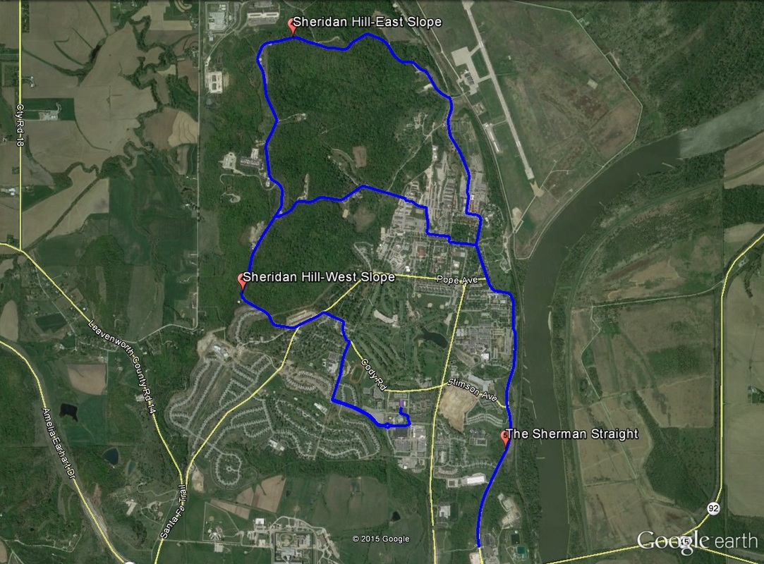 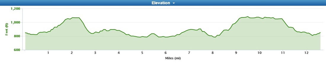 Here's where things get tricky. See the embedded video at the end of this section for a nice course recon video provided by Leavenworth Triathlon Club. Exit to the bike course happens at the southern-most edge of transition, between swim-in and run-out. Cyclists take an immediate left on to Monroe, an immediate right on to 4th, and another immediate right on to Iowa Avenue to the main stretches of bike route. Out of transition is downhill, which gives a nice boost to the outbound trek. The opening meters to Iowa Ave comes with a roundabout. Head straight through it (2nd exit) on to Biddle. The road starts to edge upward for a touch on the right-hand turn heading north on Biddle Blvd. The bump (although a touch steep) is short-lived, and the road evens out. Take a left on Cody Road, which will bend left and turn in to 9th Cavalry before taking an immediate left on to Hancock Avenue. This series of turns is where the course gets interesting: the first of three major climbs presents itself. This opening stretch of the climb up Sheridan Hill-West is only three-tenths of a mile, rising about 75 feet (3.6%, by my calculation). A right turn on to Sheridan Drive shows the second half of the climb after a false flat, this time up 125 feet in the same distance, giving it a nearly 6% average grade (over 10% in spots). Look for the water tower -- that will mark the end of the first climb as the road bends right. Cyclists ride past the Fort's gun range before taking a right off Sheridan and on to McPherson. This begins a very fast plummet down all 250 feet climbed up Sheridan West. Be aware during this section: last year there were some really rough roads, and even a few potholes as riders enter back in to town along McPherson. Also be aware of the quick right-left kink in the road right on the entrance in to town (where a lot of those potholes are) -- A LOT of speed is going to have to be scrubbed to make this kink safely. See Leavenworth Tri Club's video below for a good idea of where to expect the rough roads (seriously...it's very helpful). Just beyond the entrance in to town -- approaching 3 miles in to the route -- the road pitches upwards for a couple of "speed bumps," as riders turn right on to Waterhouse, followed by an quick left on to Organ, and another quick right-left kink (McClellan-to-Kearney). A right turn from Kearney to Scott Avenue begins another descent. Scott turns in to the long run south on Sherman Avenue. As riders approach the Sherman Avenue turn-around, the road climbs a touch upward -- but it is short-lived. Beyond the turn-around, though, the second of the three climbs on-route begins: a reverse of the elevation lost as riders hit Scott/Sherman Avenue south-bound. As the road veers right off of Scott (again, formerly Sherman) and on to Grant Avenue, climbing stops. The road veers left and turns in to McPherson Avenue. A quick left after McPherson puts riders on Bluntville, including a nice 120-foot descent (that doesn't require braking, finally). Then comes Sheridan Hill-East with a slight left on to Sheridan Road. This is, by far, the largest of the three climbs, broken in to three separate sections (or rather, a continuous climb with two false-flats along the way). This behemoth lasts 1.15 miles and pitches up at an average 5.5% -- a total of just over 300 feet. Starting a mile 8, it definitely wears on the legs. Leavenworth Triathlon Club's course recon video gives a nice look at this climb. Finally, the fall from the wall. After a stretch of flat road, riders will once again see the water tower from earlier in the ride, this time marking the start of a long descent. Unfortunately, much of the resulting speed will have to be scrubbed -- the remainder of the route is a reversal of the opening three miles of the bike leg, including all of the quick turns and switch-backs. Just be sure to turn left off Biddle and on to Iowa -- last year I made the mistake of missing the turn. For flying-dismount-ers, look to the roundabout on Iowa for a good place to pull your feet. Remember: the exit out of transition was downhill, so the entrance will be slightly upward, making last-minute attempts a bit impossible. Run Leg 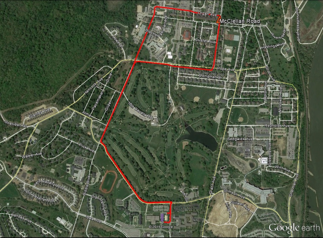 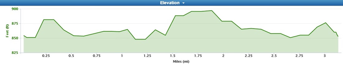 The run route also presents with a not-so-flat course -- be mindful of that coming off the bike.
A simple "lollipop loop," runner start off heading out of the southeast corner of transition, due-east to 4th Street. Right off the bat, the left turn on to 4th Street shows a touch of climbing -- all the 500-or-so feet to Cody Road. OF NOTE: CONTINUE STRAIGHT THROUGH CODY ROAD TO THE MULTI-USE TRAIL ON THE NORTH SIDE. There will be volunteers helping out, so it shouldn't be too terribly difficult to miss. As the trail bends right, a touch more climbing comes before a nice easy descent along the remainder of Cody before the right turn on to Biddle Boulevard. Northbound on Biddle is mostly flat (technically a positive net grade. Turn right on Pope Avenue, followed by a left up McClellan. The northbound trek up McClellan shows the only significant climb on the run route, a quarter-mile climb up almost 50 feet at 3.5% average grade. The climb tops out at the left turn on to Organ Avenue. The second half of Organ Avenue is a downhill, as is the first half of the left turn heading south on Biddle. The final mile is a reverse of the opening mile, including a small climb on the multi-use trail along Cody Road. On the way in, don't forget: the finish line is BEFORE the turn in to transition. Just look for the inflatable finish chute. That's all I got! Go forth and conquer! -tds ~~__o _-/<,_ @/ @ |
